
- elevation 2,079 m (6,821 ft) Length 175 km | - elevation 5 m (16 ft) | |
 | ||
- left Mabaca River, Saltan River, Pasil River - right Bunog River, Tanudan River, Biga River - location | ||
The Chico River (Spanish: Rio Chico de Cagayan) is a river system in the Philippines in the island of Luzon, encompassing the regions of Cordillera and Cagayan Valley.
Contents
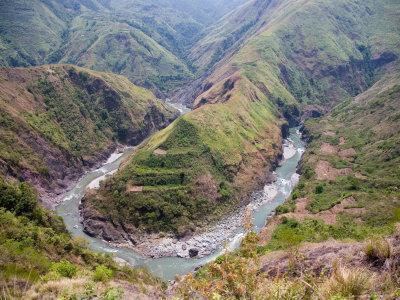
Map of Chico River, Philippines
The most extensive river in the Cordillera region, it covers the provinces of Mountain Province, Kalinga and Cagayan. It is one of the major tributaries of the Cagayan River.
It is referred to as a "river of life" for the Kalinga people who live on its banks, and is well known among development workers because of the Chico River Dam Project, an electric power generation project which local residents resisted for three decades before it was finally shelved in the 1980s - a landmark case study concerning ancestral domain issues in the Philippines.
Geography
The Chico has a length of 174.67 kilometers and is a tributary of the Cagayan River.
Source and course
The highest headwaters begin along the slopes of Mount Data in the Cordillera mountains at Bauko, Mountain Province. It then flows northeastward through Bontoc, Sabangan, Sadanga, Tinglayan, Lubuagan, Tabuk City, Pinukpuk, Tuao, Piat, Rizal, and finally at Santo Niño, where it merges with the Cagayan River.
Its tributaries are the Bunog River to the south, The Tanudan and Biga Rivers to the east, The Mabaca and Saltan Rivers to the North, and the Pasil River further downstream.