
Airport type Public Website Chickasha.org/airport/ Phone +1 405-222-6006 | Owner City of Chickasha Elevation AMSL 1,152 ft / 351 m Code CHK | |
 | ||
Address 2344 Beechcraft Rd., Chickasha, OK 73018, USA Similar Chickasha Municipal Swimming, Chickasha City Public Works, Chickash Crime Stoppers, Chickasha Office Supply, Chickasha City Land Fill | ||
Chickasha Municipal Airport (IATA: CHK, ICAO: KCHK, FAA LID: CHK) is a city owned, public use airport located three nautical miles (6 km) northwest of the central business district of Chickasha, a city in Grady County, Oklahoma, United States. It is included in the National Plan of Integrated Airport Systems for 2011–2015, which categorized it as a general aviation facility.
Contents
Facilities and aircraft
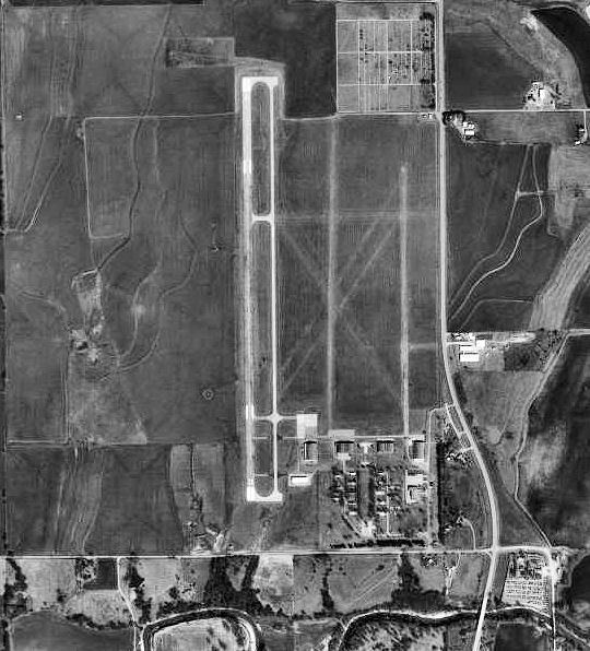
Chickasha Municipal Airport covers an area of 720 acres (291 ha) at an elevation of 1,152 feet (351 m) above mean sea level. It has one paved runway designated 17/35 with a concrete surface measuring 5,101 by 100 feet (1,555 x 30 m). It also has two unpaved runways with turf surfaces: 18/36 is 2,840 by 145 feet (866 x 44 m) and 2/20 is 2,525 by 100 feet (770 x 30 m).
For the 12-month period ending November 8, 2010, the airport had 4,000 general aviation aircraft operations, an average of 10 per day. At that time there were 36 aircraft based at this airport: 80% single-engine, 17% multi-engine, and 3% helicopter.
History
Opened in October, 1941 as Wilson-Bonifils Field, the airport conducted contract basic flying training for the United States Army Air Forces. The contractor was the Wilson-Bonfils Flying Schools. Flying training was performed with Fairchild PT-19s as the primary trainer. Also had several PT-17 Stearmans and a few P-40 Warhawks assigned. The wartime airport had up to six grass runways, with the runways being changed at various times.
Appears that there may have been four auxiliaries associated with Chickasha - Aux #1, Aux #2, Aux #3 & Aux #4 but unconfirmed and location unknown.
Inactivated on 1 May 1945 with the drawdown of AAFTC's pilot training program. The airfield was turned over to civil control at the end of the war though the War Assets Administration (WAA).