
Population 727 (in 2011) Civil parish Cherhill Local time Saturday 7:06 AM | OS grid reference SU038701 Unitary authority Dialling code 01249 | |
 | ||
Weather 4°C, Wind S at 10 km/h, 97% Humidity | ||
British english culture the white horse of cherhill doingenglish
Cherhill is a village and civil parish in Wiltshire, England. The village is about 2 1⁄2 miles (4 km) east of the town of Calne, on the A4 road towards Marlborough. The parish includes the village of Yatesbury.
Contents
- British english culture the white horse of cherhill doingenglish
- Map of Cherhill Calne UK
- Cherhill wiltshire crop circle 23 7 2016
- Overview
- Location
- History
- Cherhill White Horse and Oldbury Hill Fort
- The Cherhill Gang
- Sundial
- Parish church
- Governance
- Amenities
- References
Map of Cherhill, Calne, UK
Cherhill wiltshire crop circle 23 7 2016
Overview
Cherhill has a population of around 700 with a mixture of housing ranging from thatched cottages (some dating to the 14th century) to newly-built detached houses. The River's Brook rises in the northeast of the village and flows west towards Quemerford, where it joins the River Marden.
Cherhill is known for the Cherhill White Horse cut into the chalk hillside in 1780, the Landsdowne obelisk on the Cherhill Downs, and the crop circles that appeared in the fields at the bottom of the Downs. The area around the horse and obelisk is owned by the National Trust. On a clear day, the 840 ft (260 m) summit offers fine views, up to 25 miles, with the water tower at Tetbury in Gloucestershire visible. Atop the tall hill to the north of the village, opposite to Cherhill Downs, it is said to be possible to see the Severn crossings to South Wales, 38 miles (61 km) to the west.
Location
Cherhill lies on an old coaching road, now called the A4, which runs from central London to Bristol. Its nearest railway station is Chippenham on the Great Western line, which is a stop for direct services between London Paddington and Bristol Temple Meads. The nearest motorway junction is junction 17 of the M4 north of Chippenham, 15 miles (24 km) away from Cherhill. The village is served by the Wigglybus scheme, which runs from Cherhill and other surrounding villages into nearby Calne and connects to further transport links.
History
John Marius Wilson's Imperial Gazetteer of England and Wales (1870–1872) says of Cherhill:
Near the village is the Lansdowne Monument, or Cherhill Monument, a 125-foot stone obelisk erected in 1845 by the Third Marquis of Lansdowne in honour of his ancestor Sir William Petty.
The civil parish increased in size in 1934, when Cherhill gained some land from Calne Without and absorbed the whole of Yatesbury parish.
Cherhill White Horse and Oldbury Hill Fort
The Cherhill White horse was cut out of the hillside in 1780. It has been restored several times due to chalk being washed away and weeds growing on it. The horse is visible from miles around and has become a landmark synonymous with the village and local area. The most recent restoration to the delicate chalk carving took place in 2006.
In 2005, the horse was covered in black stripes to give it more of an exotic appearance; the owners of a local car franchise were attempting to make it appear more like a panda (although it more closely resembled a zebra), as a publicity stunt to help launch a new vehicle of the same name.
The top of the National Trust owned Cherhill Downs is home to the neolithic settlement, Oldbury Hill Fort. From here it is possible to see the route of an ancient Roman road heading toward the nearby Wansdyke trade route. The top of the hill is popular with ramblers, dog walkers and power kiters, owing to the powerful winds in action.
The Cherhill Gang
The Cherhill Gang was a notorious group of highway men who operated in the 18th century on the London to Bath main road (A4) which passes through the village – they were noted for their robbery technique of attacking the carriages of rich Londoners while completely naked, thus shocking passengers into handing over their money and also making it harder to identify them. A painting depicting one such attack can be seen in the Black Horse pub, on the A4 main road in the village.
Sundial
At one of the village's bus shelters is a millennium project of a sundial. Consisting of a vertical sarsen stone inside a face of Roman numerals, it symbolises the passage of time.
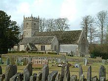
Parish church
The Church of England parish church of St James has 12th-century origins. Most of the building, including the tower, is from the 15th century. A west gallery in Gothic style was added in 1840, and restoration in 1863 was by S.B. Gabriel. The church was designated as Grade II* listed in 1960.
Cherhill was a dependent church of Calne parish until 1842. Since 1973 the parish has been part of the Oldbury Benefice.
Governance
The Parish Council has a mostly consultative role, while the Wiltshire Council unitary authority is responsible for all significant local government functions. The parish forms part of the North Wiltshire parliamentary constituency.
Amenities
Cherhill has a primary school, built at Middle Lane in 1961 to replace a small school on The Street which was built in 1846 or 1847.
The village hall was built in 1977, next to the old school. In 2015 a new building was proposed, on a larger site immediately east of the village boundary.
Cherhill Cricket Club play in the Wiltshire League. The village has a pub, the Black Horse.