
Country United States Area code(s) 539/918 Elevation 198 m Population 3,371 (2013) | Time zone Central (CST) (UTC-6) FIPS code 40-13650 Zip code 74426 Local time Friday 4:56 PM | |
 | ||
Weather 20°C, Wind S at 21 km/h, 17% Humidity Area 23.31 km² (23.05 km² Land / 26 ha Water) | ||
How to say or pronounce usa cities checotah oklahoma
Checotah is a town in McIntosh County, Oklahoma, United States. It was named for Samuel Checote, the first chief of the Creek Nation elected after the Civil War. The population was 3,481 at the 2000 census. According to Census 2010, the population has decreased to 3,335; a 4.19% loss.
Contents
- How to say or pronounce usa cities checotah oklahoma
- Map of Checotah OK 74426 USA
- History
- Geography
- Demographics
- Popular culture
- Notable people
- References
Map of Checotah, OK 74426, USA
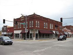
Checotah is home to numerous antique malls, a Civil War battle site and a downtown historic district. Checotah claims to be the steer wrestling capital of the world. Early boosters called Checotah, "The Gem of the Prairie.
History
The Missouri–Kansas–Texas Railroad (also known as the MKT or Katy) established a railhead on the old Texas Road in 1872 that would become the site of present-day Checotah. Although it was named Checote Switch for Samuel Checote, a later mapmaker spelled the name as Checotah. The town was chartered by the Creek Nation in 1893. The Dawes Commission held its first meeting here.
Between 1907 and 1909, the people of Checotah were involved in a dispute with nearby Eufaula known as the McIntosh County Seat War. After Checotah was designated as the new county seat, the people of Eufaula refused to hand over the county records. Soon after, a group of heavily armed men from Chectotah attempted to seize the records from the courthouse in Eufaula, but were beaten back and forced to surrender during the gunfight that followed. Eufaula was designated as the permanent seat of McIntosh County one year later.
Geography
Checotah is located at an elevation of 652 feet (199 m) at the intersection of I-40 and U.S. Route 69. Nearby is Eufaula Lake, the largest-capacity lake in the state of Oklahoma.
According to the United States Census Bureau, the city has a total area of 9.0 sq mi (23 km2). 8.9 square miles (23 km2) of it is land and 0.1 square miles (0.26 km2) of it (0.67%) is water.
Demographics
As of the census of 2000, there were 3,481 people, 1,389 households, and 912 families residing in the city. The population density was 389.3 per square mile (150.3/km²). There were 1,576 housing units at an average density of 176.3 per square mile (68.1/km²). The racial makeup of the city was 67.91% White, 6.92% African American, 15.91% Native American, 0.23% Asian, 0.09% Pacific Islander, 0.40% from other races, and 8.53% from two or more races. Hispanic or Latino of any race were 1.29% of the population.
There were 1,389 households out of which 31.5% had children under the age of 18 living with them, 44.9% were married couples living together, 17.7% had a female householder with no husband present, and 34.3% were non-families. 31.5% of all households were made up of individuals and 18.4% had someone living alone who was 65 years of age or older. The average household size was 2.39 and the average family size was 2.98.
In the city, the population was spread out with 26.1% under the age of 18, 8.2% from 18 to 24, 23.7% from 25 to 44, 20.3% from 45 to 64, and 21.7% who were 65 years of age or older. The median age was 39 years. For every 100 females there were 77.7 males. For every 100 females age 18 and over, there were 72.5 males.
The median income for a household in the city was $22,029, and the median income for a family was $30,741. Males had a median income of $26,094 versus $17,298 for females. The per capita income for the city was $15,921. About 16.1% of families and 20.4% of the population were below the poverty line, including 23.4% of those under age 18 and 7.6% of those age 65 or over. The median house value is $50,500.