
OS grid reference TQ758722 Post town ROCHESTER Local time Friday 7:27 PM UK parliament constituency Strood | Sovereign state United Kingdom Postcode district ME3 Dialling code 01634 | |
 | ||
Weather 9°C, Wind SE at 11 km/h, 81% Humidity | ||
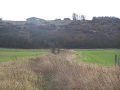
Chattenden is a small village in Hoo Parish, in the unitary authority of Medway in South East England. It was, until 1998, part of Kent and is still ceremonially associated via the Lieutenancies Act. At the 2011 Census the population was included in the civil parish of Hoo St. Werburgh. It lies to the north of the A228 and the village of Wainscott, at the top of Four Elms Hill.
Contents
Map of Chattenden, Rochester, UK
Origins
Chattenden means 'Forest Settlement' from the elements ceto and ham dun. It is recorded in 1100 as Chetindunam, and Chatindone in 1281.
Geography and ecology
Turning left on the A228 on the brow of Four Elms Hill, leads onto Kitchener Road, that eventually leads itself to the Great Chattenden Woods, designated as an SSSI, due to the diversity of insects, birds, plants and trees found there. To the south of Chattenden is Towerhill Wood, also known as Coxham Wood, with has Public Footpaths that lead into Lower Upnor, where the Arethusa Venture Centre and the Medway Yacht Club (MYC) are located. Along the A228, (which becomes the Ratcliffe Highway in Chattenden), was once a pub known as 'The Old George'.
Military history
In 1875 the War Office built five magazines on a hillside at Chattenden. This facility expanded and a nearby site at Lodge Hill was established in 1899. These sites, which became known as Chattenden and Lodge Hill Military Camps, were put up for sale in 2016.