
 | ||
Similar Bradgate Park, Beacon Hill - Leicestershire, Swithland Wood, The National Forest, Beacon Hill Country Park | ||
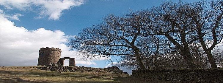
Bradgate park charnwood forest leicestershire 26th january 2011 england hd
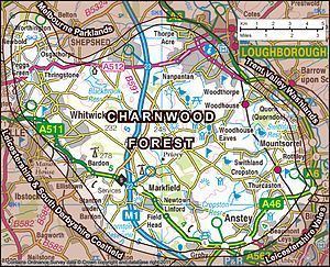
Charnwood Forest is an upland tract in north-western Leicestershire, England, bounded by Leicester, Loughborough and Coalville. The area is undulating, rocky and picturesque, with barren areas. It also has some extensive tracts of woodland; its elevation is generally 600 ft (180 m) and upwards, the area exceeding this height being about 6,100 acres (25 km2). The highest point, Bardon Hill, is 912 ft (278 m). On its western flank lies an abandoned coalfield, with Coalville and other former mining villages, now being regenerated and replanted as part of the National Forest. The M1 motorway, between junctions 22 and 23, cuts through Charnwood Forest.
Contents
- Bradgate park charnwood forest leicestershire 26th january 2011 england hd
- ExtentEdit
- GeologyEdit
- HistoryEdit
- In literatureEdit
- Wildlife and geological sitesEdit
- References
The hard stone of Charnwood Forest has been quarried for centuries, and was a source of whetstones and quern-stones. The granite quarries at Bardon Hill, Buddon Hill and Whitwick are of national importance and supply crushed aggregate, much by train, to a wide area of southern Britain.
The forest is an important recreational area with woodland walks, noted for their displays of bluebells in the early spring, rock climbing and hillwalking. Popular places with public access include Bardon Hill, Beacon Hill, Bradgate Park, Swithland Wood and the Outwoods and Stoneywell Cottage (National Trust ).
ExtentEdit
The area of hills and open land known as Charnwood Forest has no jurisdictional boundary. (The Borough of Charnwood covers roughly two thirds of Charnwood Forest, and the eastern half of the borough is not part of the forest). Furthermore, despite its name, Charnwood was never a royal forest, and was never subject to forest law. So although it is an ancient and well established locality, it has only recently been officially defined, by the Natural England national character area (NCA) process, which takes a somewhat wider definition than many previous attempts to define the area.
GeologyEdit
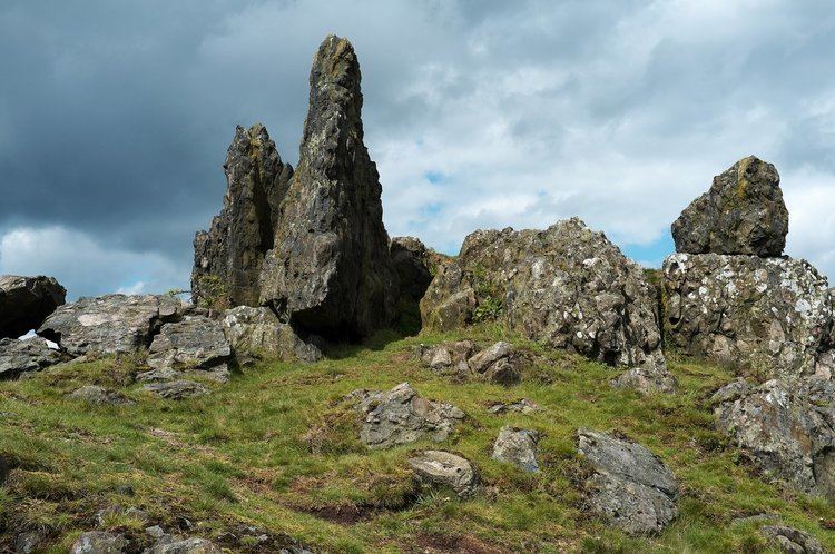
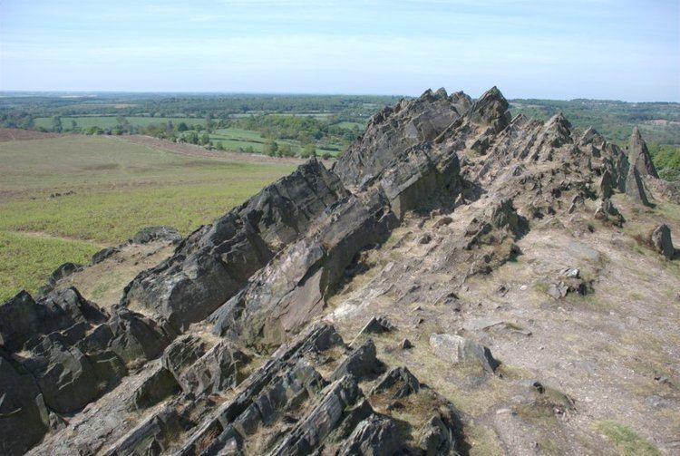
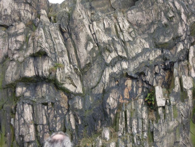
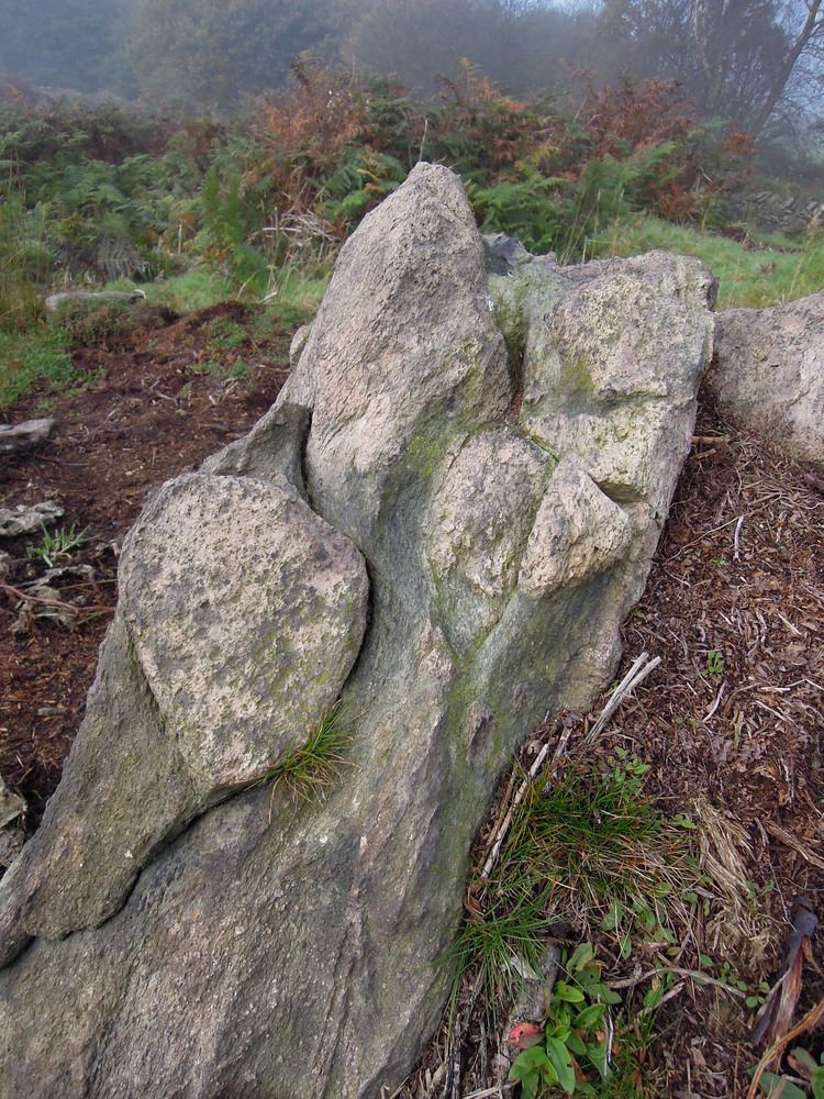
Many of the craggy rocks of Charnwood Forest are of volcanic origin and are very old, dating back through 600 million years to Precambrian times. It was the site of the first ever recorded discovery of Charnia masoni, the earliest known large, complex fossilised species on record. It was discovered in 1957 by a local schoolboy named Roger Mason (thus masoni) who, with friends, was exploring a quarry near the Charnwood village of Woodhouse Eaves. The rocks of Charnwood Forest remain the only place in Western Europe where these Precambrian fossils have been found. Along the western edge of Charnwood Forest the rocks are mainly Precambrian igneous Diorites. These formed from molten lava deep within the sedimentary rocks, cooling slowly to produce hard, blocky rock with large crystals. This is extensively quarried for roadstone around Groby, Markfield and Whitwick, and is known as granite (formerly also called Markfieldite). The central area of the forest has older rocks still. These are sedimentary and are very variable in character, They were formed by material from volcanoes, settling in deep water, and it is in these beds that the fossils are found. Uplifting, tilting and erosion have produced the distinctive jagged outcrops found across the highest parts of Charnwood. On the eastern side, a much more recent series of rocks are found. Again igneous Diorites, that formed deep underground, but these are Ordovician, from a mere 450 million years ago. These are extensively quarried in the areas near Mountsorrel.
HistoryEdit
The earliest form of the name Charnwood is probably derived from cerne woda, from the Celtic carn, meaning cairn, and the Old English wudu, meaning wood. Some sources give cwern as the derivation, meaning a tool used to grind grain and other materials by hand. The area was a source of stone for these tools, called quern-stones.
Archeological evidence has shown that the area was inhabited as far back as the Neolithic period, approximately 4,000–2,000 BC. Beacon Hill is the site of a Bronze Age hill fort, dating from between 600 BC – 43 AD. This forms one of the last surviving visible features in the landscape known to the Coritani, the tribe who occupied most of the East Midlands area at the time of the Roman Conquest.
According to Domesday Book, there was only one settlement in Charnwood Forest in 1086, at Charley whose name would appear to come from the same root, with the suffix -ley denoting open land, rather than forest.
In the 200 years after the Norman conquest, newly created settlements took major areas of land out of the forest for use in agriculture. Quorn was established between 1086 and 1153, and all the land up to Woodhouse had been reclaimed from the forest by 1228.
There were comparatively few major changes in land use in the post Medieval period, until the demand for timber and charcoal for the early Industrial Revolution contributed to a further loss of woodland. By the end of the 18th century, most of the woodland had disappeared leaving large areas of moorland and pasture.
In literatureEdit
The area was the inspiration for "Charnwood Poems", a collection of poems by the author, playwright and poet Albert Francis Cross (1863–1940). It is also the setting for the speculative fiction novel "Some Kind of Fairy Tale" by Graham Joyce (2012), in which it is depicted as a possible portal to the realm of fairies.
Wildlife and geological sitesEdit
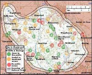
Charnwood Forest covers approx 67 sq mi (170 km2) of Leicestershire, split over three local government districts: Charnwood Borough, North West Leicestershire District and Hinckley and Bosworth District. It includes a national nature reserve (NNR), 19 SSSIs (Some subdivided in the list of sites below), 4 GCR sites of international geological importance plus a further 6 GCR sites, 13 Regionally Important Geological Sites (RIGS), five local nature reserves (LNRs), seven Leicestershire and Rutland Wildlife Trust (LRWT) nature reserves, and 1 Woodland Trust woodland. 17 sites have open access to the public. Footpaths and bridleways give views and limited access to the other sites listed, and to the rest of the Charnwood Forest landscape. Over half of Charnwood Forest is included within the English National Forest. It is also crossed by two waymarked long distance walking routes – the Leicestershire Round and the Ivanhoe Way. The 45 sites listed here include sites with statutory wildlife or geological designations, plus other sites included in published lists of notable sites. On both the map and table, green denotes a site open to the public, amber denotes a site with limited access or restricted by permit or membership. Red denotes a site with no public access except by special arrangement with the owners.
Abbreviations used in the table: National nature reserve (NNR). Site of Special Scientific Interest (SSSI) (B=Biological, G=Geological). Geological Conservation Review (GCR)(I=of International importance). Regionally Important Geological Site (RIGS). Leicestershire and Rutland Wildlife Trust (LRWT). National Trust (NT). Local nature reserve (LNR).