
OS grid reference SU176241 Dialling code 01725 | Sovereign state United Kingdom Postcode district SP5 | |
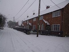 | ||
Charlton-All-Saints is a settlement in the civil parish of Downton, in Wiltshire, England. It is located immediately to the west of the River Avon, about 4 miles (6.4 km) south of Salisbury.
Contents
Map of Charlton-All-Saints, Salisbury, UK
The village has a population of around 450. There are several traditional thatched cottages, of which a few are from the 17th century, and the majority mid-18th century. Charlton House, at the junction of Warrens Lane and Lower Road, has a granary and a barn from the late 18th century.
The Avon Valley Path, a long-distance footpath between Salisbury and the Dorset coast, passes through the village.
History
The settlement has existed since Saxon times. The name "Charlton" derives from the Old English #eorl t#n, t#n meaning farm or settlement and #eorl being the lowest rank of free peasant in Anglo-Saxon England. The suffix "All Saints" is taken from the dedication of the village's church. Sources and road signs differ as to whether the name should be hyphenated.
By 1208, Charlton was a tithing of the parish of Downton. In the 14th century it was a prosperous farming community, highly assessed for taxation. In 1851, the Charlton and Witherington tithings were united to form an ecclesiastical parish, which then had considerable secular duties. In 1897, after the creation of civil parishes, this ecclesiastical parish was united with Standlynch to form the civil parish of Standlynch with Charlton-All-Saints. This was finally merged into Downton parish in 1934.
Charlton had a small school for girls from 1786, and a National School from c. 1858 which was designed by William Butterfield. This school could accommodate 99 but attendance fell during the 20th century and it was closed in 1968.
Church and chapel
The Anglican church, All Saints', was built in 1851 partly at the expense of Lord Nelson, owner of the Trafalgar estate on the other side of the river. Construction is in brick to designs of T.H. Wyatt, in Early English style. The font is by William Butterfield and the west windows by Morris. Today the church is part of the Chalke Valley benefice.
Butterfield also designed the vicarage on Lower Road, built in brick in 1860-62.
A Wesleyan Methodist chapel was built near All Saints' in 1864, and became a private house in the 1970s.