
Last eruption 4040 BCE ± 150 years | ||
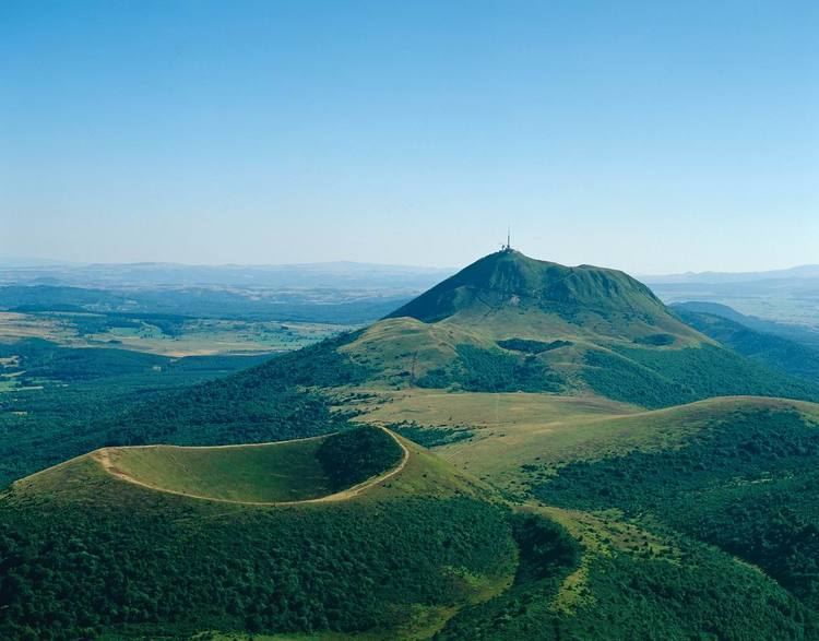 | ||
Elevation max. 1,464 m (4,803 ft) at Puy de Dôme Age of rock From 7,000 to 95,000 years Similar Puy de Dôme, Puy de Sancy, Vulcania, Monts Dore, Puy de la Vache | ||
Origins of earth cha ne des puys faille de limagne
The Chaîne des Puys ([ʃɛn de pɥi]) is a north-south oriented chain of cinder cones, lava domes, and maars in the Massif Central of France. The chain is about 40 km (25 mi) long, and the identified volcanic features include 48 cinder cones, eight lava domes, and 15 maars and explosion craters. Its highest point is the lava dome of Puy de Dôme, located near the middle of the chain. The name of the range comes from a French term, puy, that refers to a volcanic mountain with a rounded profile.
Contents
- Origins of earth cha ne des puys faille de limagne
- Map of ChaC3AEne des Puys 63680 Chastreix France
- Du sancy au puy de d me la cha ne des puys vue du ciel
- References
Map of Cha%C3%AEne des Puys, 63680 Chastreix, France
The chain is famous in the history of volcanology, as it was the subject of the pioneering research of English geologist George Julius Poulett Scrope, starting in the 1820s. In 1827 he published his classic Memoir on the Geology of Central France, including the Volcanic formations of Auvergne, the Velay and the Vivarais, which was later re-published in a revised and somewhat more popular form in The Geology and extinct Volcanos of Central France in 1858. These books were the first widely published descriptions of the Chaîne des Puys, and the analysis therein laid the foundation for many of the basic principles of volcanology.
A date of 4040 BCE is usually given for the last eruption of a Chaîne des Puys volcano.