
Elevation 2,500 m | ||
 | ||
Similar | ||
Cerro Sarisariñama is a tepui, a flat-topped mountain in Jaua-Sarisariñama National Park at the far south-west of Bolívar State, Venezuela, near the border with Brazil. Its altitude range is 300–2,350 metres. The name of the mountain originates from the tale of local Ye'kuana Indians about an evil spirit living in caves up in the mountain and devouring human flesh with a sound "Sari... sari...".
Contents
Map of Cerro Sarisari%C3%B1ama, Bol%C3%ADvar, Venezuela
The tepui is in one of the most remote areas in the country, with the closest road being hundreds of miles away.
Size
Similar to other tepuis, Sarisariñama consists of quartzite of the Roraima formation, belonging to Paleoproterozoan. The summit area of Sarisariñama tepui is 546.88 km² and the slope area is 482 km².
Biology
Sarisariñama is unique among tepuis, with a 15–25 metre-high forest fully covering the top of it. This isolated ecosystem is especially rich with numerous endemic species of plants and animals.
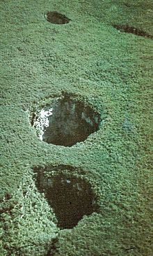
Sinkholes
The most distinctive features of this tepui are its sinkholes. There are four known sinkholes. Two, Sima Humboldt and Sima Martel, are visually unusual, huge, and well known, with isolated forest ecosystems covering their bottoms. The largest one, Sima Humboldt, is up to 352 metres wide and 314 metres deep. Another Sarisariñama sinkhole, the 1.35 km long Sima de la Lluvia, has been very important for exploration of the processes of erosion on tepuis.
Exploration
Sarisariñama became a much sought destination for exploration after 1961, when pilot Harry Gibson noticed both enormous sinkholes. The summit of Sarisariñama was reached only in 1974, with a helicopter. Initial investigations were done at both sinkholes, including a descent to the bottom of Sima Humboldt. A more thorough speleological investigation was done two years later, in 1976 by a joint Venezuelan-Polish expedition. They discovered one more sinkhole, Sima de la Lluvia. For some two decades it was the longest known quartzite cave (1.35 km) in the world and its exploration to a great extent solved the mystery of the formation of these sinkholes.
Currently access to Sarisariñama is restricted to scientific researchers.