Neha Patil (Editor)

Central Frontenac

Updated on
Edit
Like
Comment
Share on FacebookTweet on TwitterShare on LinkedInShare on Reddit
Country
  
Canada

Incorporated
  
1998

Postal Code
  
K0H

Province
  
Ontario

County
  
Frontenac

Time zone
  
EST (UTC-5)

Population
  
4,556 (2011)

Area code
  
613

Central Frontenac httpsuploadwikimediaorgwikipediacommonsthu

Website
  
www.centralfrontenac.com

Where is central frontenac


Central Frontenac is a township in eastern Ontario, Canada in the County of Frontenac.

Contents

Map of Central Frontenac, ON, Canada

Central Frontenac was created in 1998 through an amalgamation of the Townships of Hinchinbrooke, Kennebec, Olden and Oso.

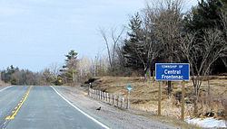
Ontario road 509 central frontenac highway 7 to plevna


Communities

There are 21 communities:

  • Arden, web site http://www.ardenvillageontario.com/
  • Ardendale
  • Bordenwood
  • Burke Settlement
  • Camp Oconto 44.686°N 76.673°W / 44.686; -76.673
  • Clarendon Station 44.874°N 76.696°W / 44.874; -76.696
  • Cole Lake
  • Crow Lake
  • Echo
  • Elm Tree
  • Godfrey
  • Henderson
  • Kirk Cove 44.793°N 76.984°W / 44.793; -76.984
  • Long Lake 44.690°N 76.763°W / 44.690; -76.763
  • McLean 44.654°N 76.834°W / 44.654; -76.834
  • Mountain Grove 44.734°N 76.844°W / 44.734; -76.844
  • Oak Flats 44.548°N 76.741°W / 44.548; -76.741
  • Oconto 44.721°N 76.675°W / 44.721; -76.675
  • Oso 44.819°N 76.684°W / 44.819; -76.684
  • Parham
  • Piccadilly 44.733°N 76.948°W / 44.733; -76.948
  • Ronaldson 44.683°N 77.033°W / 44.683; -77.033
  • Seouls Corners 44.782°N 76.800°W / 44.782; -76.800
  • Sharbot Lake
  • Tichborne
  • Wagarville 44.640°N 76.803°W / 44.640; -76.803
  • Wilkinson 44.533°N 76.812°W / 44.533; -76.812
  • Zealand 44.834°N 76.620°W / 44.834; -76.620
  • Education

    Central Frontenac, along with South Frontenac, North Frontenac and the Frontenac Islands, send students to schools part of the Limestone District School Board, based in neighboring Kingston.

    Demographics

    According to the 2006 Statistics Canada Census:

  • Private dwellings occupied by usual residents: 1852 (total dwellings: 3243)
  • Mother tongue:
  • English as first language: 93.1%
  • French as first language: 1.2%
  • English and French as first language: 0.2%
  • Other as first language: 5.5%
  • Population trend:

  • Population in 2011: 4556
  • Population in 2006: 4665
  • Population in 2001: 4557
  • Population in 1996:
  • Hinchinbrooke (township): 1328
  • Kennebec (township): 968
  • Olden (township): 906
  • Oso (township): 1413
  • Population in 1991:
  • Hinchinbrooke (township): 1117
  • Kennebec (township): 765
  • Olden (township): 811
  • Oso (township): 1361
  • Transportation

    The main road is Highway 7 which runs through the entire township from east to west. County Road 38 intersects Highway 7 at Sharbot Lake and runs south to Kingston.

    The route of the former Kingston and Pembroke Railway runs through the township, and has been converted into the K&P Rail Trail.

    References

    Central Frontenac Wikipedia


    Similar Topics