
Type Road Route number(s) State Route 24 | Length 663 km (412 mi) | |
 | ||
Major cities | ||
Driving the central arnhem road
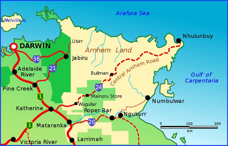
The Central Arnhem Road, also known as the Central Arnhem Highway and Bulman Track is a designated state route in the Northern Territory of Australia providing the main overland access to the East Arnhem Region and the mining town of Nhulunbuy on the Gove Peninsula. The route traverses Aboriginal owned land for most of its length, and road conditions vary with the vast majority being unsealed and prone to seasonal flooding. Permits from the Northern Land Council are required for non-indigenous persons to travel its length. Due to road conditions, four-wheel drive vehicles are recommended and permits will not be granted to tow caravans. Owing to its remoteness, only two locations along the track offer fuel - the Mainoru Store, 200 km (120 mi) from the junction with the Stuart Highway and in the town of Bulman.
Contents
- Driving the central arnhem road
- Map of Central Arnhem Rd Northern Territory Australia
- Video 252 stuart highway central arnhem road turn off and onwards 30km
- References
Map of Central Arnhem Rd, Northern Territory, Australia
In 2014, a regional roads funding package was announced by the federal government which included $7.7 million for upgrades to the Donydji, Goyder and Mainoru River crossings, as well as allocation from the $90 million Northern Territory Roads Productivity Package for the construction of a bridge over Rocky Bottom Creek.
Australian 4WD Action ranked the Bulman Track 5th in its list of 20 "must drive" four-wheel drive tracks in Australia in 2010.