
Country United States County Chase Time zone CST (UTC-6) Elevation 380 m Zip code 66843 Local time Tuesday 1:03 AM | FIPS code 20-11425 Area 21 ha Population 27 (2013) Area code 620 | |
 | ||
Weather 7°C, Wind NW at 39 km/h, 32% Humidity | ||
Cedar Point is a city in Chase County, Kansas, United States. As of the 2010 census, the city population was 28.
Contents
- Map of Cedar Point KS 66843 USA
- Early history
- 19th century
- Geography
- Area attractions
- Demographics
- 2010 census
- 2000 census
- Government
- Primary and Secondary Education
- Transportation
- Utilities
- References
Map of Cedar Point, KS 66843, USA
Early history
For many millennia, the Great Plains of North America was inhabited by nomadic Native Americans. From the 16th century to 18th century, the Kingdom of France claimed ownership of large parts of North America. In 1762, after the French and Indian War, France secretly ceded New France to Spain, per the Treaty of Fontainebleau.
19th century
In 1802, Spain returned most of the land to France. In 1803, most of the land for modern day Kansas was acquired by the United States from France as part of the 828,000 square mile Louisiana Purchase for 2.83 cents per acre.
In 1806, Zebulon Pike led the Pike expedition westward from St Louis, Missouri, of which part of their journey followed the Cottonwood River through Chase County near the current city of Cedar Point.
In 1854, the Kansas Territory was organized, then in 1861 Kansas became the 34th U.S. state. In 1855, Marion County was established within the Kansas Territory, which included the land for modern day Cedar Point.
In 1862, Cedar Point was founded. The first post office in Cedar Point was established in 1862.
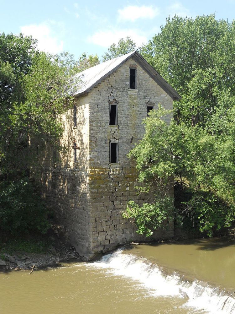
In 1867, a log dam was built across the Cottonwood River, and a wooden-frame mill was constructed for sawing lumber. The following year (1868) it was converted to grind flour and named Cedar Point Mill. In 1870, the name was changed to Drinkwater & Schriver Mill. In 1871, construction of the current stone structure was started, then completed in 1875. In 1884, the log dam was replaced by a stone dam.
In 1871, the Atchison, Topeka and Santa Fe Railway built a main line east-west and built a nearby station named Cedar Grove in the valley north of Cedar Point. In 1996, it merged with Burlington Northern Railroad and renamed to the current BNSF Railway. Most locals still refer to this railroad as the "Santa Fe".
Geography
Cedar Point is located at 38°15′39″N 96°49′18″W (38.260888, -96.821662), in the scenic Flint Hills of the Great Plains. According to the United States Census Bureau, the city has a total area of 0.08 square miles (0.21 km2), all of it land.
Area attractions
Cedar Point has two listings on the National Register of Historic Places (NRHP).
Demographics
Cedar Point is part of the Emporia Micropolitan Statistical Area.
2010 census
As of the census of 2010, there were 28 people, 13 households, and 5 families residing in the city. The population density was 350.0 inhabitants per square mile (135.1/km2). There were 25 housing units at an average density of 312.5 per square mile (120.7/km2). The racial makeup of the city was 96.4% White and 3.6% from two or more races.
There were 13 households of which 23.1% had children under the age of 18 living with them, 30.8% were married couples living together, 7.7% had a male householder with no wife present, and 61.5% were non-families. 46.2% of all households were made up of individuals and 38.5% had someone living alone who was 65 years of age or older. The average household size was 2.15 and the average family size was 3.60.
The median age in the city was 51.5 years. 28.6% of residents were under the age of 18; 0% were between the ages of 18 and 24; 10.7% were from 25 to 44; 32% were from 45 to 64; and 28.6% were 65 years of age or older. The gender makeup of the city was 53.6% male and 46.4% female.
2000 census
As of the census of 2000, there were 53 people, 22 households, and 13 families residing in the city. The population density was 782.8 people per square mile (292.3/km2). There were 28 housing units at an average density of 413.5 per square mile (154.4/km2). The racial makeup of the city was 94.34% White, 1.89% Native American, and 3.77% from two or more races.
There were 22 households out of which 13.6% had children under the age of 18 living with them, 50.0% were married couples living together, 13.6% had a female householder with no husband present, and 36.4% were non-families. 31.8% of all households were made up of individuals and 13.6% had someone living alone who was 65 years of age or older. The average household size was 2.41 and the average family size was 3.00.
In the city, the population was spread out with 22.6% under the age of 18, 17.0% from 18 to 24, 18.9% from 25 to 44, 24.5% from 45 to 64, and 17.0% who were 65 years of age or older. The median age was 38 years. For every 100 females there were 96.3 males. For every 100 females age 18 and over, there were 95.2 males.
As of 2000 the median income for a household in the city was $28,750, and the median income for a family was $36,250. Males had a median income of $40,000 versus $42,500 for females. The per capita income for the city was $16,102. There were no families and 3.6% of the population living below the poverty line, including no under eighteens and none of those over 64.
Government
The Cedar Point consists of a mayor and three council members. The council meets the 1st Tuesday of each month at 6:00 p.m.
Primary and Secondary Education
Cedar Point is part of Unified School District 284. All students attend schools in Cottonwood Falls.
Cedar Point schools were closed through school unification. The Cedar Point High School mascot was Cedar Point Bronchos.
Transportation
U.S. Route 50 highway and BNSF Railway passes east-west near the city.