
Country United States Time zone Central (CST) (UTC-6) Zip code 66845 Local time Monday 10:32 PM | Elevation 1,204 ft (367 m) Area code 620 Population 874 (2013) | |
 | ||
Weather 11°C, Wind NW at 37 km/h, 15% Humidity Points of interest Roniger Memorial Museum, Chase County Historical Society, Swope Park | ||
Music at the emma the emma chase cafe cottonwood falls kansas w the good sam club august 4 2012
Cottonwood Falls is the largest city and county seat of Chase County, Kansas. As of the 2010 census, the city population was 903.
Contents
- Music at the emma the emma chase cafe cottonwood falls kansas w the good sam club august 4 2012
- Map of Cottonwood Falls KS 66845 USA
- Early history
- 19th century
- 20th century
- Geography
- Climate
- Area events
- Area attractions
- Demographics
- 2010 census
- 2000 census
- City
- County
- US
- Primary and Secondary Education
- Library
- Transportation
- Utilities
- Gallery
- Notable people
- Fiction
- References
Map of Cottonwood Falls, KS 66845, USA
Early history
For many millennia, the Great Plains of North America was inhabited by nomadic Native Americans. From the 16th century to 18th century, the Kingdom of France claimed ownership of large parts of North America. In 1762, after the French and Indian War, France secretly ceded New France to Spain, per the Treaty of Fontainebleau.
19th century
In 1802, Spain returned most of the land to France. In 1803, most of the land for modern day Kansas was acquired by the United States from France as part of the 828,000 square mile Louisiana Purchase for 2.83 cents per acre.
In 1854, the Kansas Territory was organized, then in 1861 Kansas became the 34th U.S. state. In 1859, Chase County was established within the Kansas Territory, which included the land for modern day Cottonwood Falls.
The first settlement in the area of Cottonwood Falls was in 1854, when an Indian trader named Seth Hayes founded a cattle ranch on the Cottonwood River close to the mouth of Diamond Spring Creek. The area around the town was organized as Chase County in 1859, and Cottonwood Falls was designated the temporary county seat. Other early settlers arrived in Cottonwood and surrounding lands in 1856 to 1858.
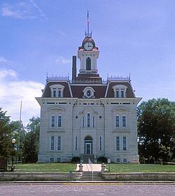
The first post office in Cottonwood Falls was established in 1858. In 1873 the city's French Renaissance style Chase County courthouse was built; at roughly the same time, the Atchison, Topeka and Santa Fe Railway reached Cottonwood Falls area. Through the late 19th and early 20th centuries the area around the city was mainly divided into farms and cattle ranches.
20th century
In 1931, Transcontinental & Western Air Flight 599 crashed ten miles south of Cottonwood Falls near the community of Bazaar, killing all eight on board, including Notre Dame University football coach Knute Rockne. A monument to the crash is located on private property.
There have been numerous floods during the history of Cottonwood Falls. In June and July 1951, due to heavy rains, rivers and streams flooded numerous cities in Kansas, including Cottonwood Falls. Many reservoirs and levees were built in Kansas as part of a response to the Great Flood of 1951.
Geography
Cottonwood Falls is located at 38°22′5″N 96°32′35″W (38.368159, -96.542918), in the scenic Flint Hills of the Great Plains. According to the United States Census Bureau, the city has a total area of 0.60 square miles (1.55 km2), of which 0.59 square miles (1.53 km2) is land and 0.01 square miles (0.03 km2) is water.
Climate
The climate in this area is characterized by hot, humid summers and generally mild to cool winters. According to the Köppen Climate Classification system, Cottonwood Falls has a humid subtropical climate, abbreviated "Cfa" on climate maps.
Area events
Area attractions
Cottonwood Falls has five listings on the National Register of Historic Places (NRHP).
Demographics
Cottonwood Falls is part of the Emporia Micropolitan Statistical Area.
2010 census
As of the census of 2010, there were 903 people, 342 households, and 205 families residing in the city. The population density was 1,530.5 inhabitants per square mile (590.9/km2). There were 414 housing units at an average density of 701.7 per square mile (270.9/km2). The racial makeup of the city was 93.9% White, 3.4% African American, 0.2% Asian, 1.1% from other races, and 1.3% from two or more races. Hispanic or Latino of any race were 7.0% of the population.
There were 342 households of which 28.7% had children under the age of 18 living with them, 46.8% were married couples living together, 9.4% had a female householder with no husband present, 3.8% had a male householder with no wife present, and 40.1% were non-families. 37.1% of all households were made up of individuals and 21.7% had someone living alone who was 65 years of age or older. The average household size was 2.22 and the average family size was 2.92.
The median age in the city was 43.3 years. 20.2% of residents were under the age of 18; 8.7% were between the ages of 18 and 24; 24.9% were from 25 to 44; 23.1% were from 45 to 64; and 23.3% were 65 years of age or older. The gender makeup of the city was 49.8% male and 50.2% female.
2000 census
As of the census of 2000, there were 966 people, 375 households, and 227 families residing in the city. The population density was 1,674.9 people per square mile (643.1/km²). There were 427 housing units at an average density of 740.3 per square mile (284.3/km²). The racial makeup of the city was 94.93% White, 2.38% African American, 1.14% Native American, 0.21% Asian, 0.83% from other races, and 0.52% from two or more races. Hispanic or Latino of any race were 2.38% of the population.
There were 375 households out of which 28.3% had children under the age of 18 living with them, 47.2% were married couples living together, 11.7% had a female householder with no husband present, and 39.2% were non-families. 34.4% of all households were made up of individuals and 20.5% had someone living alone who was 65 years of age or older. The average household size was 2.27 and the average family size was 2.93.
In the city, the population was spread out with 23.2% under the age of 18, 6.1% from 18 to 24, 29.6% from 25 to 44, 18.1% from 45 to 64, and 23.0% who were 65 years of age or older. The median age was 39 years. For every 100 females there were 91.7 males. For every 100 females age 18 and over, there were 90.7 males.
As of 2000 the median income for a household in the city was $28,947, and the median income for a family was $37,986. Males had a median income of $27,639 versus $19,167 for females. The per capita income for the city was $15,166. About 8.8% of families and 11.6% of the population were below the poverty line, including 15.0% of those under age 18 and 8.6% of those age 65 or over.
City
The Cottonwood Falls government consists of a mayor and five council members; the council meets the first and third Monday of each month at 7:00 p.m. City Council Members are elected in odd-numbered years and serve four-year terms.
County
U.S.
Primary and Secondary Education
Cottonwood Falls is part of Unified School District 284.
The Chase County High School mascot is Chase County Bulldogs.
The former Cottonwood Falls High School mascot was Cottonwood Falls Wildcats.
Library
Transportation
K-177 highway passes north-south through the city. Chase County Airport, FAA:9K0, located south-east of 8th St and Airport Rd.
Utilities
Gallery
Notable people
Fiction
In Disney's 1985 film Return to Oz, Doctor J.B. Worley's Clinic is set in Chase County near Cottonwood Falls.