
Local time Monday 7:04 PM | ||
 | ||
Weather -1°C, Wind W at 10 km/h, 56% Humidity Points of interest Orofino Winery, Eauvivre Winery & Vinyards, Crowsnest Winery, Rustic Roots Winery, Little Farm Winery | ||
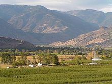
Cawston (2006: Population approximately 973) is an unincorporated small community in the south Similkameen Valley.
Contents
Map of Cawston, BC, Canada
The community was named for R.L. Cawston, a pioneer rancher and magistrate who settled in the area in the 19th century. Nearby was the site of the original Hudson's Bay Company store.
School
Many of the kids in Cawston attend either Cawston Primary School or Similkameen Elementary Secondary School
Geography
Cawston is located on Highway 3 (the Crowsnest Highway) nearby communities are Keremeos (8 km to the West), Osoyoos (36 km to the East), and Penticton (50 km to the North).
Economy
Today, Cawston is a busy agricultural center. The town has two fruit packing plants, the newest being built strictly for organic produce - a fast-growing segment of the area's agricultural economy.
There are many apple and soft fruit orchards throughout the Cawston area. In recent years, vineyards and wineries have become an important part of the local economy.
The rural nature of this community has also made it a popular home to horse ranches, hobby farms and nature enthusiasts. There are many hiking trails in the area covering almost every terrain possible, from cactus and sagebrush desert to sub-alpine meadows.
Skiing and other winter activities can be enjoyed nearby as can 18 hole golf course at Twin Lakes, boating and swimming throughout the Okanagan and fishing in the Similkameen and Ashnola rivers as well as on the many lakes in the area.