
Regional district Okanagan-Similkameen Founded 1909 Elevation 365 m Population 1,330 (2011) | Incorporated 1956 Time zone PST (UTC-8) Area 211 ha Local time Sunday 5:26 AM | |
 | ||
Weather 3°C, Wind W at 6 km/h, 76% Humidity | ||
16 04 20 happy 420 back in keremeos bc
Keremeos /kɛrəˈmiːəs/ is a village in the Southern Interior of British Columbia, Canada. The name originated from the Similkameen dialect of the Okanagan language word "Keremeyeus" meaning "creek which cuts its way through the flats" referring to Keremeos Creek which flows down from the Upper Benchlands to the Similkameen River that runs by the village. Local legend claims the name means "the meeting of the winds" and joke that the only time it's calm is when the wind blows equally from all four directions.
Contents
- 16 04 20 happy 420 back in keremeos bc
- Map of Keremeos BC Canada
- Driving through keremeos town bc fruit stands agricultural british columbia canada
- Economy
- Geography
- History
- Indian reserves and governance
- Climate
- Television
- Schools
- References
Map of Keremeos, BC, Canada
Driving through keremeos town bc fruit stands agricultural british columbia canada
Economy
Keremeos' main industries are horticulture, agriculture, ranching, and wine making, among others. Fruit stands are also a major component of the local economy, making it the self-titled "fruit stand capital of Canada." All sorts of soft fruits, apples, cherries, peaches, etc. and vegetables are grown in the South Similkameen's dry warm climate, and vineyards and wineries are quickly being added as the valley's wine-growing potential is being recognized.
Area attractions include Cathedral Provincial Park, the Red Bridge, the Keremeos Columns, the Keremeos Grist Mill, excellent fishing in area lakes and rivers, Apex Mountain Resort, Twin Lakes Golf Resort, Spotted Lake, the Hedley Mining Museum and the Mascot Mine.
Geography
The geography of the Keremeos area ranges from cottonwood groves along the river, to dense orchards and farms, to desert-like landscapes along the bases of the surrounding mountains, up to alpine peaks and plateaux on top.
History
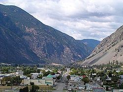
With K Mountain as a backdrop, Keremeos, BC is a community, whose "Wild West" looks date back to 1909 when the postmaster of the now-abandoned community of Upper Keremeos, Mr. George Kirby, purchased land alongside the Similkameen River in anticipation of the V.V. & E. Railway passing through the area. He was right and other businesses soon followed. Keremeos was officially incorporated in 1956.
Indian reserves and governance
The head offices of the Lower Similkameen Indian Band are located in Keremeos. Two of their reserves, Keremeos Forks Indian Reserve Nos. 12 & 12A are located 6-7 miles north of the town towards Kaleden, just south of the Green Mountain Road junction, while Alexis Indian Reserve No. 9 is located about 4 miles west of town on Highway 3. The most populated of the band's reserves are at Chopaka, where Reserves Nos 7 & 8 abut the border with the United States. Many of the band's reserves are located around Cawston, which is just southeast of Keremeos. 12 and 12A do not belong to LSIB (Lower Similkameen Indian Band) private property.
Climate
Keremeos has a semi-arid climate (Köppen BSk) with cool but short winters and hot, dry summers. Precipitation is low at 323 millimetres (13 in) and evenly distributed throughout the year.
Television
Keremeos was featured on the historical television series Gold Trails and Ghost Towns, Season 3, Episode 12.
Schools
Schools within or near the Keremeos area include Cawston primary school, Penticton High School, Maggie, Osoyoos, Princeton, and Similkameen Elementary Secondary School.