
Location Ontario, Canada Season Year-round Province Ontario | Trail difficulty Easy Length 104,000 m | |
 | ||
Use Hiking, cycling, jogging, horseback riding, cross-country skiing, snowshoeing, and with a permit: snowmobiling Trailheads Smiths Falls, Strathcona Township | ||
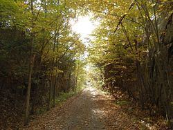
The Cataraqui Trail is a 104-km Rails-to-Trails multi-use linear recreational trail in Eastern Ontario, Canada. The route passes by farmland, woods, lakes, and wetlands. The trail begins southwest of Smiths Falls, at a parking lot south of Ontario Highway 15 designated as kilometre zero. Numbered posts are situated every one to five kilometres. In its midsection the trail crosses the UNESCO Frontenac Arch Biosphere Reserve. The 78.2 km segment running from Smiths Falls to Harrowsmith is part of the Trans Canada Trail. The Rideau Canal is crossed on a 1912 railway trestle at Chaffey's Locks, near kilometre post 42. The K&P Rail Trail intersects the Cataraqui Trail at Harrowsmith. Both the main Rideau Trail and its blue-blazed side trails share the Cataraqui Trail right-of-way in several places. Trail's end is reached at Strathcona near Napanee. Access points and parking lots are dotted along the route.
Contents
Map of Cataraqui Trail, Ontario, Canada
The route runs along the roadbed of the former Canadian National Railway (CN). Most of the railbed was donated to the Cataraqui Region Conservation Authority (CRCA) by CN in 1997. Some sections are privately owned but where access has been granted. Except for emergency and maintenance vehicles, and snowmobiles with an Ontario Federation of Snowmobile Clubs permit in winter, motorized travel is not permitted.