
Country France Canton Aubagne-Est Area 26.86 km² | Population (2008) 7,793 Local time Monday 6:25 AM | |
 | ||
Weather 12°C, Wind NW at 8 km/h, 73% Humidity Points of interest Cap Canaille, Plage de la Grande Mer, Casino Barrière, Cassis Calanques Plongée, Plage Bleue | ||
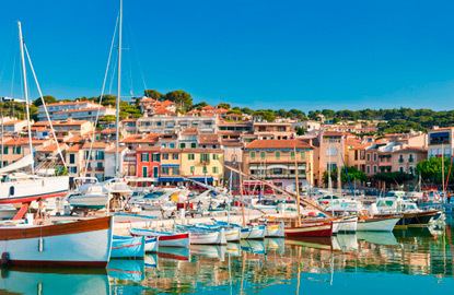
Cassis ([kasi]; Occitan: Cassís) is a commune situated east of Marseille in the department of Bouches-du-Rhône in the Provence-Alpes-Côte d'Azur region in southern France.
Contents
- Map of 13260 Cassis France
- Geography
- History
- Industrial Revolution
- Twin towns sister cities
- Notable residents
- References
Map of 13260 Cassis, France
It is a popular tourist destination, famous for its cliffs (falaises) and the sheltered inlets called calanques. The wines of Cassis are white and rosé, and not to be confused with crème de cassis, a specialty of Burgundy which takes its name from blackcurrants (cassis), not the commune.
Geography
The town is situated on the Mediterranean coast, about 20 kilometres (12.4 miles) east of Marseille. Cap Canaille 394 metres (1,293 feet), between Cassis and La Ciotat ("the civitas") is one of the highest maritime bluffs in Europe, a sailor's landmark for millennia. It is east of Marseille and in the department of Bouches-du-Rhône. One of its main beach, called "Bestouan" is made cooler by a karstic source.
History
The site where Cassis now sits was first occupied between 500 and 600 BC by the Ligures, who constructed a fortified habitation at the top of the Baou Redon. These people lived by fishing, hunting, and by farming.
The link with Massilia (Marseille), a city founded by the Phoceans,(Greek: Φώκαια), means that the current site of Cassis could have been inhabited by the Greeks, though no proof has yet been found.
During the Roman times, Cassis was part of the maritime route made by the Emperor Antoninus Pius. At this time, the port advanced right up to Baragnon. It was a small village, established mainly around the Arena and Corton beaches. The principal livelihood was fishing and maritime trade with North Africa and the Middle East. Several archaeological discoveries attest to this.
From the fifth to the tenth century, invasions by foreign tribes led the population to seek refuge in the castrum, a fortified city that, in 1223, became the property of the Seigneurie des Les Baux-de-Provence.
In the fifteenth century, Cassis was ceded to the Counts of Provence, then René of Anjou gave the town to the Bishops of Marseille, who ruled the town until the Revolution of 1789.
Industrial Revolution
In the eighteenth century, Cassis started to develop outside the ramparts of the fortified city and around the port. After the Bourbon Restoration, new industries developed here, including the drying of cod, the manufacture of olive oil and clothing, coral work, wine-making and the exploitation of local stone (cement, limestone). Stone of Cassis, which was quarried here since antiquity made the town famous. It has been used for the quays of the large Mediterranean ports (Alexandria, Algiers, Piraeus, Marseille, and Port Said. A claim that it was used for the base of the Statue of Liberty in New York City gained wide circulation but has been proved apocryphal. Today, the stone is used more for domestic purposes such as the construction of sinks and fireplaces.
In the twentieth century, as these industries began to disappear, the workforce turned to tourism and wine making. Cassis was one of the first three vineyards to profit from the appellation d'origine contrôlée (label of controlled origin) introduced in 1936.
Twin towns – sister cities
Cassis is twinned with: