
 | ||
Ashmore and cartier islands national anthem
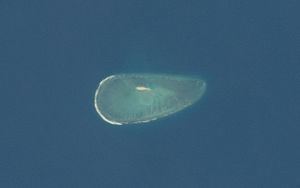
Cartier Island is an uninhabited and unvegetated sand cay in a platform reef in the Timor Sea north of Australia and south of Indonesia. According to the Commonwealth of Nations, the land area of the Cartier Islands is 0.004 square kilometers (0.4 hectares). It is located at 12°31'S 123°33'E, on the edge of the Sahul Shelf, about 300 kilometres off the north west coast of Western Australia, 200 kilometres south of the Indonesian island of Roti, and 70 kilometres south-east of Ashmore Reef. It is within the Territory of Ashmore and Cartier Islands, an external territory of Australia.
Contents
- Ashmore and cartier islands national anthem
- Map of Cartier Island
- History
- Cartier Island Commonwealth Marine Reserve
- Fishing
- References
Map of Cartier Island
At the southern edge of the reef is a shipwreck of the Ann Millicent, an iron-hulled barge of 944 tons wrecked in 1888. The remains of an RAAF Beaufighter can also be seen at low tide. Formerly used as a bombing range, access to the island is prohibited because of the risk of unexploded ordnances. The area is still a gazetted Defence Practice Area, but is no longer in active use.
Cartier Island is completely unvegetated except for the seagrass Thallassia hemprichii, which grows in pockets of sand within the reef, and may be exposed at low tide.
History
The island was charted in 1800 and named after the ship Cartier. Its charted position was somewhat inaccurate until corrected in 1878 during a hydrographic survey by Lieutenant William Tooker in the Airlie. On 5 January 1888 the Ann Millicent was wrecked on the island during a voyage from the Gulf of Carpentaria to Adelaide, South Australia. In 1909 it was annexed by the United Kingdom, but on 23 July 1931 both Ashmore Reef and Cartier Island was transferred to Australia. During World War II it was used as a bombing range.
Cartier Island Commonwealth Marine Reserve
The area within 4 nautical miles (7 km) of the centre of the reef is protected as the Cartier Island Commonwealth Marine Reserve (formerly Cartier Island Marine Reserve). It was declared a Marine Reserve in June 2000. The Reserve is part of the North-west Commonwealth Marine Reserve Network, one of the Protected areas of Australia.
The Reserve comprises an area of approximately 172 km2 (66 sq mi), and extends to a depth of 1 km (0.6 mi) below the sea floor. It includes the reef around Cartier Island, a small submerged pinnacle called Wave Governor Bank, and two shallow pools to the island's northeast.
Fishing
The Cartier Island Commonwealth Marine Reserve is in an area subject to a Memorandum of Understanding (MOU) signed by Australia and Indonesia in 1974 and reviewed in 1989, which provided for continued Indonesian traditional fishing within limits.
In 2003, environmental authorities closed maritime access to the island and its surrounding reef to build up depleted fish stocks and for safety reasons. Announced as a seven-year closure, Environment Australia planned to monitor levels of marine wildlife, and determine the presence of unexploded ordnance. Prior to that time, the area was frequented by yachts, and fished by Indonesian boats.