
Terminus Rockfall Province Papua | Length 1.4 km (0.87 mi) Status Retreating | |
 | ||
Area 0.686 km (0.265 sq mi) in 2002 | ||
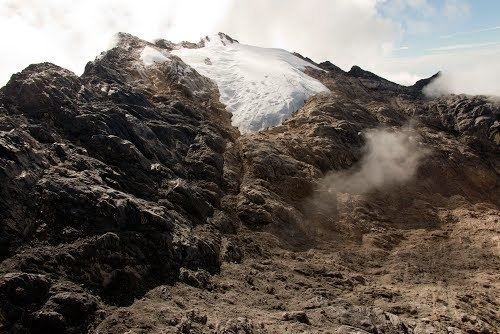
The Carstensz Glacier is near the peak of Puncak Jaya (sometimes called Mount Carstensz or the Carstensz Pyramid) which is a mountain in the Sudirman Range, western central highlands of Papua province, Indonesia. The glacier is situated at an elevation of approximately 4,600 metres (15,100 ft) and is 1.5 kilometres (0.93 mi) east of the summit tower of Puncak Jaya. The Carstensz Glacier is 1.4 kilometres (0.87 mi) in length and .60 kilometres (0.37 mi) wide.
Contents
Map of Carstensz Glacier, Tembagapura, Mimika Regency, Papua, Indonesia
The glacier is named after the 17th century Dutch explorer Jan Carstenszoon, commonly known as Jan Carstensz.
Background
Research presented in 2004 of IKONOS satellite imagery of the New Guinean glaciers indicated that in the two years from 2000 to 2002, the Carstensz Glacier had lost a further 6.8% of its surface area. An expedition to the remaining glaciers on Puncak Jaya in 2010 discovered that the ice on the glaciers there is about 32 metres (105 ft) thick and thinning at a rate of 7 metres (23 ft) annually. At that rate, the remaining glaciers in the immediate region near Puncak Jaya are expected to last only to the year 2015.
The remaining remnant glaciers on Punkak Jaya were once part of an icecap that developed approximately 5,000 years ago. At least one previous icecap also existed in the region between 15,000 and 7,000 years ago, when it also apparently melted away and disappeared.