
North end Autopista Norte | ||
 | ||
South end Avenida Primero de Mayo | ||
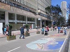
Carrera s ptima bogot artistas callejeros en bogota
Carrera Séptima (Seventh Street), also known as Eduardo Posada Flórez Avenue, is one of the principal transit arteries which crosses the eastern side of Bogotá north and south. It is the most important thoroughfare of the city in the sense of history, culture, economy, and society. Carrera Séptima is bound to the east by the Eastern Hills.
Contents
- Carrera s ptima bogot artistas callejeros en bogota
- Map of Cra 7a BogotC3A1 Colombia
- Points of interest
- Usaqun
- Chapinero
- Santa Fe
- La Candelaria
- References
Map of Cra. 7a, Bogot%C3%A1, Colombia
Points of interest
Carrera Séptima passes through the localities of Usaquén, Chapinero, Santa Fe, and La Candelaria.
Usaquén
Chapinero
Santa Fe
La Candelaria
References
Carrera Séptima Wikipedia(Text) CC BY-SA