
 | ||
6417 russell rd carlsbad springs ontario josee turpin
Carlsbad Springs is a rural community on Bear Brook in Cumberland Ward in Ottawa, Ontario, Canada; Prior to amalgamation in 2001, the community was on the border between Gloucester and Cumberland. According to the Canada 2011 Census, the population of the surrounding area is 916 (area bounded on the north by Renaud Road and the CP Railway, 10th Line, on the east by Smith Road, Milton Road, Russell Road and Sand Road, on the south by Highway 417 and on the west by Anderson Road).
Contents
- 6417 russell rd carlsbad springs ontario josee turpin
- Map of Carlsbad Springs Ottawa ON Canada
- Mineral spa hotel era 18701930
- 1930s1970s
- 1980spresent
- References
Map of Carlsbad Springs, Ottawa, ON, Canada
Mineral spa-hotel era: 1870–1930
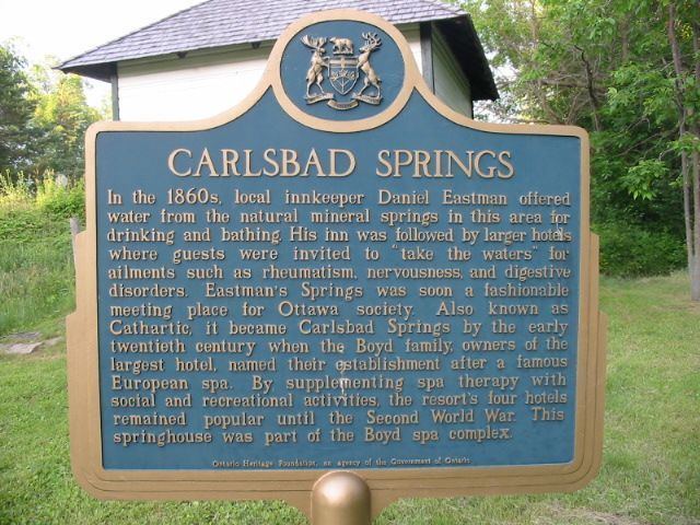
This village near Canada's capital city of Ottawa was first known as Boyd's Mills, after the proprietor of the local mill on the Bear Brook, first to process white pine lumber, later a grain mill when the land was cleared in the early 19th century and wheat farming began, later as Eastman's Springs, for Danny Eastman, who built the first inn to lodge travelers. In 1870, businessmen including future Ottawa mayor C.W. Bangs formed the Dominion Springs Company to build a spa-hotel, offering as a recreational and medical benefit the highly mineralized water found in most local wells.
In 1882, a railway through the area brought travelers from farther distant. The track is now the main railway line between Ottawa and Montreal, although a single track at Carlsbad Springs, which lost its local railway station in the 1970s.
Early in the 1900s the hotel became a successful resort, attracting the upper classes of nearby Ottawa. As well as mineral waters and sulphur baths, they enjoyed guest lecturers, walking paths, horseback riding facilities, archery, billiards, and lawn games, and the mineral water was bottled and sold throughout North America. As a marketing device the village was in 1906 renamed Carlsbad Springs after the most fashionable aristocratic resort in central Europe (now Karlovy Vary, Czech Republic,) where King Edward VII regularly took holidays. The resort spa did not survive the Depression of the 1930s. The all-wood hotel, the largest in the county for many years, became apartments in 1945 and was demolished in the 1980s.
1930s–1970s
Family farms and the big hotel helped the community grow in the late 19th and early 20th centuries, but Carlsbad Springs' boom as a resort ended in the Great Depression of the 1930s, and by World War II, the resort and spa business dwindled. Most of the surrounding land was small dairy or chicken farms (up to 200 acres).
Unsuccessful official planning altered the local economy in the 1960s when the Ontario government proposed rebuilding Carlsbad Springs as a commuter city outside Ottawa's Green Belt (200 km2.). Keen to co-operate, the National Capital Commission started acquiring farmland nearby, to provide the satellite city with its own Green Belt. Only then did it come to light that the local Leda clay soil cannot support tall buildings. Plans for the satellite city were abandoned, but the NCC retained thousands of acres of farmland, with no plans for whether or how it might be used. Some of the land was rented to farmers, but these diminished as the agricultural economy shrank in the 1980s.
1980s–present
As Carlsbad Springs was conveniently accessible from the main highway that runs through Ottawa (highway 417), it was attractive to commuters with jobs in the city. By the 1980s, gradual development took place in Carlsbad Springs, with modest homes on large, treed lots. Nonetheless, a semi-rural feel was maintained, due to the absence of subdivisions, and to the continued existence of a range of agricultural activities, ranging from berry-picking farms, horse-related businesses (e.g., equestrian boarding facilities), and hobby farms.
Franco-Ontarian culture has a dominant influence on the area, which can be seen in the French-language signs and in the active presence of spoken French in homes and community activities. In the wintertime, snowmobiling is both a well-loved Carlsbad Springs activity and a practical way of traveling throughout the area, as attested by the snowmobile trails that run alongside the areas' major roads. The carnival is a popular event held every Winter at the end of January at Harkness Park and the Carlsbad Springs Community Centre (6020 Piperville Road).
In the mid-1990s, one of the remaining spring houses was restored, so that the community would be able to remember Carlsbad Springs' past as a bustling resort and spa area. As well, Carlsbad Springs continued to attract other development, including a large golf course that was built close to highway 417. When Carlsbad Springs was amalgamated into the City of Ottawa, there was a mixed response from the community. While some residents were pleased that city services such as bus transportation would be available, other residents were concerned that the City of Ottawa's urban bylaws and regulations would stifle the area's semi-rural lifestyle.
A new community centre for Carlsbad Springs opened in 2011 at a cost of $3.2 million. The architect for the centre is the same one as the Shenkman Art Centre in Orléans. The Community Centre has a gymnasium, a multi-purpose room, a meeting room, a small office and a lobby area. Harkness Park, with its baseball field, a tennis court, a kids playground area, the new community centre and the surrounding facility will become the sports and leisure hub for the Carlsbad Springs community and rural east Ottawa.
The community is served by a low-power 15 watts tourist and community radio station, CJRO-FM, which operates at 107.7 MHz (FM) and is owned by the Carlsbad Springs Community Association. The name of the radio station is Carlsbad Info Radio and broadcast from the Carlsbad Springs Community Centre.
External website (Carlsbad Springs Community Association): www.carlsbadsprings.ca