
Country Canada Incorporated 1890 (town) Area 8.83 km² Population 9,809 (2011) | Province Ontario Incorporated 1870 (village) Time zone EST (UTC-5) Local time Friday 5:50 AM Area code Area codes 613 and 343 | |
 | ||
Weather -14°C, Wind NW at 10 km/h, 73% Humidity | ||
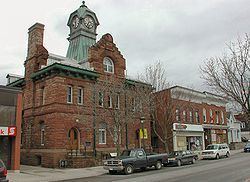
Nice place to visit great place to live carleton place
Carleton Place is a town in Eastern Ontario, Canada, in Lanark County, about 46 kilometres (29 mi) west of downtown Ottawa. It is located at the crossroads of Highway 15 and Highway 7, halfway between the towns of Perth, Almonte, Smiths Falls, and the nation's capital, Ottawa. The Mississippi River, a tributary of the Ottawa River flows through the town. Mississippi Lake is just upstream by boat, as well as by car.
Contents
- Nice place to visit great place to live carleton place
- Map of Carleton Place ON Canada
- Carleton place ottawa real estate ottawa living
- History
- Industry
- Notable residents
- Schools
- Sister cities
- References
Map of Carleton Place, ON, Canada
Carleton place ottawa real estate ottawa living
History
The town is situated on the edge of a large limestone plain, just south of the edge of the Canadian Shield in the deciduous forest ecoregion of North America. Carleton Place was first settled when British authorities prompted immigration to Lanark County in the early 19th century. The Morphy and Moore families were among the first to arrive. Edmond Morphy chose the site in 1819 when he realized there was potential in the area waterfall. He built a mill there and was the first of many such textile and lumber industries to reside in the area. The settlement was then known as Morphy's Falls. In 1829, the area was renamed Carleton Place, after a street in Glasgow, Scotland, when a post office was constructed. It became a village in 1870, and a town in 1890. The community's economic growth was enabled by the construction of the Brockville and Ottawa Railway later in the century. The town was also renowned for its access to Mississippi Lake, and had steamship service to Innisville on the west end of Mississippi Lake between the 1860s and 1920s. The river led to the development of the Ottawa Valley Canoe Association in 1893, which still exists today as the Carleton Place Canoe Club. The town received further recognition when a World War One fighter pilot, and town resident, Captain Arthur Roy Brown, made history by shooting down the Red Baron.
Industry
The logging industry stimulated economic development in the 19th century, with white pine logs exported to Europe. Local forests were depleted of hemlock to provide bark for the leather tanning industry. Both textile and lumber mills flourished, but none still operates. "The Findlay Foundry", founded by David Findlay in 1862, operated until 1974, making cast iron cookware and woodstoves. Some of the designs created by this company are still being made by another company. Today, the remaining mill buildings house condominiums and high-tech industry. The "Crash Position Indicator" (CPI) was manufactured and marketed in Carleton Place by Leigh Instruments Ltd.
Notable residents
Schools
The Upper Canada District School Board manages public education in Carleton Place and Lanark County, while the Catholic District School Board of Eastern Ontario is in charge of schools teaching the Catholic curriculum. Following is a list of schools in the Carleton Place area:
Sister cities
Carleton Place is an active participant in the Sister Cities program and has a relationships with the following municipalities: