
Location Lake Superior Population 0 | Territory Ontario Province Ontario | |
 | ||
Caribou island nova scotia
Caribou Island is an uninhabited island in the eastern end of Lake Superior, 22 miles (35 km) south of Michipicoten Island. It lies entirely within the territorial waters of Canada although only about three miles from the international border between Canada and the United States. It is approximately 3.5 miles (5.6 km) long and 1.5 miles (2.4 km) wide, and 1,600 acres (647 ha) in area. The interior is low scrub and bog with small lakes, Little Italy, Hambone, and Deer Lake among many unnamed ones. Several of the lakes are maintained by beavers and all are several feet above Lake Superior.
Contents
- Caribou island nova scotia
- Map of Caribou Island Unorganized Thunder Bay District ON Canada
- Cooper s island hopping boracay and caribou island
- Other islands
- References
Map of Caribou Island, Unorganized Thunder Bay District, ON, Canada
Caribou Island was considered for an emergency landing airport (YCI) during World War II but it was never built because of the proximity of the twin cities of Sault Ste. Marie, Michigan, and Sault Ste. Marie, Ontario, only about 80–90 miles SE. However an interior lake, Deer Lake on the center East side of the island, was used as an Amphibian base with a dock and ramp built by the last private owners of the island because of the unpredictable water/wave condition of Lake Superior. A small three room cabin was built on the east shore of Lake Superior adjacent to Deer Lake and the Amphibian base.
The island was privately held by a group of hunters and stocked with caribou in the late 1800s. It was considered a private hunting preserve through the early 1900s.
The caribou were very aggressive, treeing the lighthouse keeper for hours on several occasions. It is rumored that the light house keepers poached caribou and beaver.
One winter, in the 1920s, the caribou just walked off the island when the lake froze over.
Because of the Great Depression, the island was not restocked and the island was more or less abandoned by the approximately 15 owners-in-common.
The island was acquired completely by the Roys A. Ellis family in the 1960s and was transferred to the Melon Conservancy Trust in the early 1980s to never be developed.
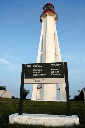
A dangerous reef stretches more than 1 mile (1.6 km) north of the north point of the island, rumored to be the one the SS Edmund Fitzgerald shoaled on. A shallow reef 2.5 miles (4.0 km) to the southwest of Caribou Island light lies only 11 feet (3.4 m) below the lake's surface. The now unmanned lighthouse which is owned by the Canadian Coast Guard is located on a tiny adjacent island called Lighthouse Island a few hundred feet across and positioned 1 mile (1.6 km) west of the southern tip of the island. When originally built, it was visible for 16 miles (26 km) and operated on a 30-second revolving cycle.
Cooper s island hopping boracay and caribou island
Other islands
There are six Caribou islands in Ontario, four of which are in Thunder Bay District. One of these Caribou Islands lies within Thunder Bay (the body of water) three km from Amethyst Harbour, Ontario and twelve km from Sleeping Giant Provincial Park at 48°31′34″N 88°50′58″W.