
Year first lit 1912 (current) Construction concrete tower Focal height 30 m | Automated mid-1970 Height 32 m Year first constructed 1886 | |
 | ||
Location Caribou Island
Lake Superior
Ontario
Canada Tower shape hexagonal tapered tower with six flying buttresses, balcony and lantern Markings / pattern white tower, red balcony and lantern | ||
Caribou island lighthouse demolition
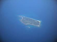
Caribou Island lighthouse sits on an uninhabited island in the eastern end of Lake Superior, 22 miles (35 km) south of Michipicoten Island. It lies entirely within the territorial waters of Canada although only about three miles from the international border between Canada and the United States. It is approximately 3 miles (4.8 km) long and approximately 1 mile (1.6 km) wide.
Contents
A dangerous reef stretches 1 mile (1.6 km) along the north and west shores of Caribou Island, and a shallow reef 2.5 miles (4.0 km) stretches beyond to the southwest to Caribou Island, lying only 11 feet (3.4 m) below the lake's surface. The unmanned lighthouse, which is owned by the Canadian Coast Guard, is located on a tiny adjacent island called Lighthouse Island a few hundred feet across and positioned 1 mile (1.6 km) west of the southern tip of the main island. When originally built, it was visible for 16 miles (26 km) and operated on a 30-second revolving cycle. Caribou Island is about 55 km (34 mi) off Agawa Bay on the east shore of the lake.
History
The present light was built in 1912 (station established 1886), flashes white every 15 seconds and is 31.5 meters (103 feet) tall. It is a hexagonal concrete tower with six flying buttresses. The structure is painted white, while the lantern, gallery and watch room are red. All other structures have been demolished and all other buildings have been removed. The lighthouse is located on a small island southwest of Caribou Island itself and about 5 km (3.1 mi) north of the international border. It is only accessible by boat.