
Country Canada Established 1831 Local time Thursday 6:19 PM Province New Brunswick | County Gloucester Time zone AST (UTC-4) Population 1,382 (2011) | |
 | ||
Weather -4°C, Wind S at 11 km/h, 91% Humidity | ||
Caraquet is a Canadian parish in Gloucester County, New Brunswick.
Contents
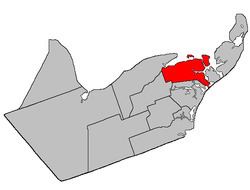
Map of Caraquet, NB, Canada
Delineation
Caraquet Parish is defined in the Territorial Division Act as being bounded:
North by Caraquet Bay and Caraquet Harbour; southeast by the Gulf of Saint Lawrence; east by a line running from the west side or entrance of Little Pokemouche Lagoon north fifty-two degrees west until it strikes the south branch of Saint Simons Inlet, and thence from the centre of the said inlet and the north entrance of Grant Shippegan Harbour to the Chaleur Bay; southwest and south by the northeast line of lot no. 1 (William Ferguson) and the prolongation thereof north thirty-six degrees west three hundred chains; thence in a direct line westerly to the northwest angle of lot no. 255, granted to P. de La Vivitiere, on the west side Maltempec Road; west by Paquetville Parish, including the islands of Caraquet and Pokesudie.Governance
The northern mainland of the parish is divided between three municipalities; from west to east, these are the eastern part of the village of Bertrand, the town of Caraquet, and the village of Bas-Caraquet. The remainder of the parish consists of four LSDs and part of a fifth; all these LSDs assess for fire protection, and all except St. Simon for first aid and ambulance services. These LSDs are:
- Grants in the southwestern corner of the parish, along Thériault, Lavigne, and Haché Roads, containing more than five thousand acres.
- Wetlands along Ruisseau à Isaac and Ruisseau à Jules.
- Ten grants between the mouth of the Saint-Simon River and the southwestern corner of Bas-Caraquet, containing about nine hundred acres.
- A small area on the southern bank of the Saint-Simon River where the Caraquet boundary cuts through a peninsula, containing less than five acres.
- Munro Island
- Caraquet Island
Communities
Parish population total does not include incorporated municipalities (in bold):
References
Caraquet Parish, New Brunswick Wikipedia(Text) CC BY-SA