
Local time Thursday 8:45 PM | ||
 | ||
Weather 3°C, Wind S at 11 km/h, 72% Humidity | ||
Car Colston is a village and civil parish in the Rushcliffe borough of Nottinghamshire. The population of the civil parish at the 2011 Census was 185. It was formerly in Bingham Rural District and before 1894 in Bingham Wapentake.
Contents
Map of Car Colston, Nottingham, UK
Location
Car Colston lies just off the A46 (the Fosse Way), 3 miles (4.8 km) north of Bingham and 2 miles (3.2 km) west of East Bridgford. It is also adjacent to Little Green, Screveton, Scarrington and Newton. There are seven buses a day between Nottingham and Newark on Trent on Mondays to Saturdays that stop at Car Colston. The nearest railway station is at Bingham, which has services every one to two hours in the Nottingham and Grantham directions.
Amenities
Since the parish is small, it has a parish meeting instead of a parish council. There are retail, medical and other services at Bingham. The village pub is the Royal Oak on The Green, which is a feature of the village.
Car Colston has a private pre-school at Old Hall Farm. There are primary schools at East Bridgford (2 miles, 3.2 km) and Bingham. Toot Hill School in Bingham is a secondary school with a sixth form and academy status.
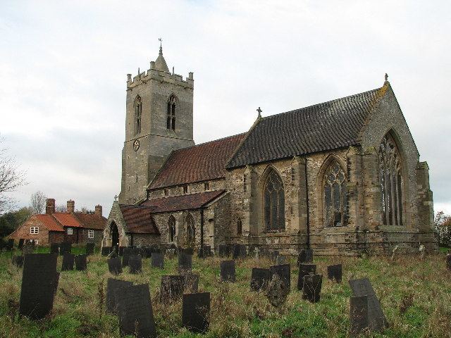
The parish church is dedicated to St Mary. It forms a joint Anglican parish with St Wilfrid's Church, Screveton. They now belong, along with Flintham, Kneeton and East Bridgford, to the Fosse Group of Parishes. A service of Holy Communion is held once a month. The Methodist church at Scarrington (1.7 miles, 2.7 km) has a Sunday evening service every other week and a Bible study group.
Toponomy
The place appears as Colestone in the Domesday survey of 1086, but as Kyrcoluiston in 1242, and variants thereof subsequently. The original affix, Old Norse kirkja, 'church', was later confusingly replaced by Middle English ker, meaning 'fenland'. The suffix seems to contain an Old Norse personal name Kolr + tūn (Old English), an enclosure; a farmstead; a village; an estate.., so 'Kolr's farm/settlement'.
Heritage
The earliest signs of human occupation date from the Bronze Age. There are remains of the foundations of a Roman villa in the south-west corner of the village. The village appears as "Colestone" in the 1086 Domesday Book, which records three manors. The two conspicuous greens (the 16½ acre Large Common and the 5½ acre Little Common) originated in the Elizabethan era. Car Colston was the home of the notable local historian Robert Thoroton (1623–1678). Most of the present-day buildings date from the 18th and early 19th centuries. The village has 13 listed historic buildings, which are listed at the end of the Conservation Area Appraisal Report.
The population of Car Colston was 152 in 1801, 213 in 1821, and 249 in 1831.
The village forms a conservation area, which was last reviewed and extended in June 2009.