
 | ||
New zealand badlands cape palliser pinnacles
Cape Palliser is a promontory on the southern coast of New Zealand's North Island and is the southernmost point of North Island - it is in fact considerably further south than Nelson or Blenheim in the South Island.
Contents
Map of Cape Palliser, New Zealand
It is located at the eastern end of Palliser Bay, 50 kilometres southeast of Wellington - 100 kilometres by road.
A small settlement - Ngāwī - is situated near Cape Palliser, where the main income comes from crayfish (southern rock lobster) fishing. Some 20 to 30 fishing boats are pushed into the sea on their trailers by bulldozers.
Kupe's Sail is another feature of Cape Palliser - a triangular upthrust of sedimentary rock shaped like a sail. Legend has it that Kupe sailed by Cape Palliser more than 1000 years ago.
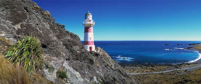
The Cape Palliser Lighthouse is located here; an unmanned lighthouse blinking once every 20 seconds. It is also home to a permanent fur seal colony.
Cape Palliser was named by Captain James Cook in honour of 'his worthy friend' Admiral Sir Hugh Palliser of the British Royal Navy.