
Clearance below 17 m Total length 1,036 m Bridge type Girder bridge | Design Concrete Girder Bridge Opened 14 March 1964 | |
 | ||
Carries Cape Coral Bridge Road (CR 867A) Maintained by Lee County Department of Transportation Similar Midpoint Memorial Bridge, Edison Bridge, Caloosahatchee Bridge, Memorial Bridge, Garcon Point Bridge | ||
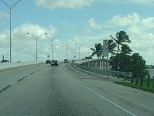
The Cape Coral Bridge is a bridge located in Southwest Florida. It spans the Caloosahatchee River connecting Fort Myers and Cape Coral. It is made up of two parallel fixed spans, each 3,400 feet (1,000 m) long.
Contents
- Map of Cape Coral Bridge Florida USA
- Catching giant tarpon at cape coral bridge florida kayak fishing report
- References
Map of Cape Coral Bridge, Florida, USA
The original span opened for traffic on March 14, 1964, with one lane in each direction. In 1989, a second parallel span opened south of the first span, with two lanes for eastbound traffic, and westbound traffic using both lanes on the original span. In conjunction with the new eastbound span, a four lane overpass was constructed over the intersection of State Road 867 (McGregor Boulevard) just east of the bridge.
The Cape Coral Bridge was the only link between Fort Myers and Cape Coral until 1997, when the Midpoint Memorial Bridge opened just north of the Cape Coral Bridge on the Caloosahatchee River.
The bridge is owned by the Lee County Department of Transportation. There is currently a two dollar toll in effect for westbound vehicles only, and there is no tolls for eastbound traffic. Florida's statewide "Sunpass" prepaid electronic toll collection system is accepted on the Cape Coral Bridge, along with Lee County's "Leeway" prepaid toll system, which is also used on the Midpoint Bridge, and the Sanibel Causeway. However, there is a variable pricing scheme in effect.