
Year first lit 1960 (current) Tower shape octagonal prism | Construction concrete tower Focal height 25 m Year first constructed 1908 | |
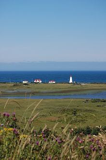 | ||
Location Cape AnguileNewfoundland and LabradorCanada Markings / pattern white tower, red balcony and lantern Original lens third-order Fresnel lens Similar Rose Blanche Lighthous, JT Cheeseman Provincial, Point Amour Lighthouse, Long Range Mountains, Lobster Cove Head Lighthouse | ||
Cape anguille lighthouse inn
The headland of Cape Anguille is near the community of Cape Anguille, Newfoundland and Labrador (where the community takes its name) at the west coast of the island of Newfoundland in the Canadian province of Newfoundland and Labrador. It is the most western point of land on the island of Newfoundland.
Contents
- Cape anguille lighthouse inn
- Map of Cape Anguille Lighthouse Highlands NL A0N 1N0 Canada
- Cape anguille
- Cape Anguille LighthouseEdit
- KeepersEdit
- References
Map of Cape Anguille Lighthouse, Highlands, NL A0N 1N0, Canada
Cape anguille
Cape Anguille LighthouseEdit
A new lighthouse was established on the cape in 1960, replacing a predecessor from 1908. It is octagonal pyramidal in shape and built in concrete. The light is emitted at a focal plane of 35 metres (115 ft) above sea level, showing a characteristic of one white flash every five seconds. A signal blast fog signal may be sounded.
KeepersEdit
Alfred Patry 1908–1943 J. Laurier Patry 1943–1983 Henry Reid 1984–1991 Leonard Patry 1991–present
References
Cape Anguille Wikipedia(Text) CC BY-SA