
Nearest city Cortez, CO Established June 9, 2000 Phone +1 970-882-5600 | Area 712.5 km² | |
 | ||
Website Canyons of the Ancients National Monument Address 9651 Rd N, Cortez, CO 81321, USA | ||
Canyons of the Ancients National Monument is a national monument protecting an archaeologically-significant landscape located in the southwestern region of the U.S. state of Colorado. The monument's 176,056 acres (71,247 ha) are managed by the Bureau of Land Management, as directed in the Presidential proclamation which created the site on June 9, 2000. Canyons of the Ancients National Monument is part of the National Landscape Conservation System, better known as the National Conservation Lands. This system comprises 32 million acres managed by the Bureau of Land Management to conserve, protect, and restore these nationally significant landscapes recognized for their outstanding cultural, ecological, and scientific values. Canyons of the Ancients encompasses and surrounds three of the four separate sections of Hovenweep National Monument, which is administered by the National Park Service. The monument was proclaimed in order to preserve the largest concentration of archaeological sites in the United States, primarily Ancestral Puebloan ruins. As of 2005, over 6,000 individual archeological sites had been identified within the monument.
Contents
- GeographyEdit
- Developmental Pueblo AD 750 to 1100Edit
- Great Pueblo period AD 1100 to 1300Edit
- Notable sitesEdit
- MigrationEdit
- Post Pueblo Native American tribes 14th to 18th centuryEdit
- European and American settlement 19th century to presentEdit
- Excavation and restorationEdit
- Canyons of the Ancients National MonumentEdit
- Wilderness study areasEdit
- Anasazi Heritage Center and Canyons of the Ancients visitor centerEdit
- VandalismEdit
- References
GeographyEdit
Canyons of the Ancients National Monument is located 9 miles west of Pleasant View, Colorado in southwestern Colorado. The monument's northern and eastern boundaries are canyons. Its western boundary is the Colorado-Utah state border. Lands south are bordered by the Ute Mountain Reservation and McElmo Creek.
Developmental Pueblo: AD 750 to 1100Edit
Ancient Pueblo people lived in the Canyons of the Ancients in the 10th century; Lowry Pueblo, built during the Great Pueblo period, was built atop pit-house built in the 10th century.
For a fuller understanding of the architecture and life style during this period, pueblo buildings in the Mesa Verde region were built with stone, windows facing south, and in U, E and L shapes. The buildings were located more closely together and reflected deepening religious celebration. Towers were built near kivas and likely used for look-outs. Pottery became more versatile, including pitchers, ladles, bowls, jars and tableware for food and drink. White pottery with black designs emerged, the pigments coming from plants. Water management and conservation techniques, including the use of reservoirs and silt-retaining dams also emerged during this period.
Great Pueblo period: AD 1100 to 1300Edit
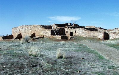
As refinements in construction techniques increased, the Puebloans built larger pueblos, or villages, on top of the pit-houses starting about AD 1090. Lowry Pueblo had just a few rooms and 2 kivas in 1090 and the village was expanded two times about 1103 and 1120 until it had 40 rooms, 8 kivas and one great kiva.
Like their ancient neighbors at Hovenweep National Monument and Mesa Verde National Park, the Lowry Pueblo dwellers were farmers and hunters. They grew beans, corn and squash and raised turkeys. They also made and decorated pottery.
Notable sitesEdit
At least 6,000 distinct structures have been identified in the monument, and the density of archeological remains is the highest of any region in the United States. The vast majority of stone structures in the national monument are from the Ancient Puebloans era.
More than 20,000 sites have been identified, in some places more than 100 sites per square mile. After building basic pit style structures at first, the Puebloans later built villages with cliff dwellings. Archaeological ruins also include Sweat lodges, kivas, shrines and petroglyphs. Reservoirs with stone and earthen dams, including spillways and also numerous check dams, built in case of flash floods. Stone towers which may have been lookout or sentry posts, are found scattered throughout the monument.
MigrationEdit
Unlike other Ancient Pueblo site abandonment, it appears that the people of the Canyons of the Ancients left the sites much earlier than their neighbors, some time in the mid-12th century. Some of the artifacts found from the site show a connection to the Chacoan culture, while others are similar to those of the Mesa Verde dwellers.
Other Ancient Pueblo people from the area migrated south to Arizona and New Mexico, ancestors to modern pueblo people such as the Hopi and Zuni. Modern Pueblo people are located on reservations primarily in New Mexico, but some in Arizona. The 60,000 people's pueblos and reservations reside in three geographic areas:
Post-Pueblo Native American tribes: 14th to 18th centuryEdit
After 1300, hunter-gathers, ancestors of the Ute and Navajo, moved into the southwestern Colorado and southeastern Utah and came to inhabit the region.
During this period, the Spanish colonial reach extended to northern New Mexico, where they settled in the 16th century. They introduced items for trade, such as guns and horses, new and deadly diseases, and cultural influence in the forms of religion, language, and forms of government. In the 18th century, Spanish missionaries visited the area looking for a route to Spanish missions in California. One of the expeditions was that of Spanish friars Silvestre Vélez de Escalante and Francisco Atanasio Domínguez who traveled from New Mexico, through western Colorado to Utah.
European and American settlement: 19th century to presentEdit
The first Anglo American people arrived in the early 19th century, starting with trappers. With the discovery of precious ores in the last decades of the 19th Century, miners and other settlers moved into the region. By the mid-19th century, the United States government and Native American tribes were at war over land ownership. People were forced to leave their homelands. The Navajo had moved south and the Ute territory was significantly reduced.
Excavation and restorationEdit
Lowry Pueblo was excavated in 1928 and went through a restoration process in 1965. Two years later, it was named a National Historic Landmark and was listed on the National Register of Historic places.
Canyons of the Ancients National MonumentEdit
The U.S. Bureau of Land Management administers the monument and enforces regulations balancing resource protection with land conservation. It was created by executive proclamation in 2000 with the intention of protecting the archaeological, natural and geological resources. Facilities at the Lowry Pueblo include parking, a picnic area, toilet and trail. Sand Canyon Pueblo also has a trail, which leads to McElmo Canyon.
Wilderness study areasEdit
There are three Wilderness study areas in the monument:
Anasazi Heritage Center and Canyons of the Ancients visitor centerEdit
The Anasazi Heritage Center is also the visitor center for the Canyons of the Ancients National Monument and includes artifacts from the monument, a museum with interactive exhibits, a library and a theatre. Information is available there regarding the Ancient Puebloan culture, Trail of the Ancients Byway and the Canyons of the Ancients National Monument.
VandalismEdit
Vandalism and treasure hunting are difficult to minimize due to an inadequate number of federal employees and law enforcement personnel to monitor and prosecute those who deface ruins or steal archeological remains. Thousands of undocumented artifacts have been removed from the monument and now reside in private collections. A news article in July 2006 reported that funding for the monument had decreased by almost 40% since 2004, and that a particularly severe looting episode occurred in January 2006.