
GNIS ID 1035898 | Length 217 km | |
 | ||
Progression Cannonball River → Missouri → Mississippi → Gulf of Mexico Source | ||
Jordan reports from cannonball river nodapl
The Cannonball River (Lakota: 'Íŋyaŋwakağapi Wakpá') is a tributary of the Missouri River, approximately 135 mi (217 km) long, in southwestern North Dakota in the United States.
Contents
- Jordan reports from cannonball river nodapl
- Map of Cannonball River West Emmons ND USA
- nodapl jordan reports from cannonball river
- References
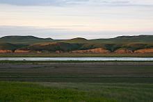
Map of Cannonball River, West Emmons, ND, USA
It rises in the Little Missouri National Grassland, in the badlands north of Amidon in northern Slope County. It flows ESE past New England, Mott, and Burt. It is joined by Cedar Creek approximately 15 mi (24 km) southwest of Shields and flows northeast, past Shields, forming the northern border of Sioux County and the Standing Rock Indian Reservation. It joins the Missouri in Lake Oahe near Cannon Ball. The cannonball concretions found in the vicinity of this river are the source of its name.
nodapl jordan reports from cannonball river
References
Cannonball River Wikipedia(Text) CC BY-SA