
- elevation 73 m (240 ft) - location Atlantic Ocean - urban 1.01 km (0 sq mi) | - elevation 2,351 m (7,713 ft) - elevation 0 m (0 ft) Area 31.72 km² | |
 | ||
- location Largo D. José Costa Nunes | ||
Candelária is a civil parish located on the western coast of the island of Pico, in the municipality of Madalena in the Azores. The population in 2011 was 822, in an area of 29.70 km².
Contents
Map of Candelaria, Portugal
History
This was the birthplace of the late cardinal José da Costa Nunes.
Geography
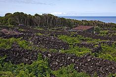
Linked by the Regional E.R.1-1ª roadway to the parishes of Criação Velha (to the north) and São Caetano (to the southeast), the parish is primarily a coastal agricultural community. From the coast, for about 2 kilometres (1.2 mi), the parish comprises cultivatable lands and settlements, which starts sloping into higher altitudes, reaching its extreme at Ponta do Pico; the parish is basically a pie-shaped wedge, with 8.6 kilometres (5.3 mi) at its extreme, along the coast. Settled areas are divided equally between hedge-row-divided parcels and forested patches of land, with scrub and natural vegetation occupying higher altitudes.
In addition to central Candelária (which also encompasses the communities of Biscoitos, Alto and Eira) there are smaller hamlets within the borders that follow the regional roadway, such as: Monte, Mirateca and Campo Raso.