
Type Ground Moraine Basin countries United States Max. width 0.3 mi (0.48 km) Area 2.626 km² Width 500 m | Primary outflows Canadice Outlet Max. length 3 mi (4.8 km) Length 4.8 km Surface elevation 334 m | |
 | ||
Location Ontario County, New York | ||
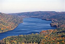
Canadice Lake /ˈkænədaɪs/ is one of the minor Finger Lakes of western New York. The lake is located approximately 30 miles (48 km) south of Rochester. The name is derived from the Iroquois word ska-ne-a-dice, meaning long lake.
Contents
Map of Canadice Lake, Canadice, NY 14560, USA
DescriptionEdit
Canadice Lake is three miles (4.8 km) long and 0.3 miles (0.48 km) wide at its widest point. The lake has a surface area of 649 acres (2.63 km2) and a maximum depth of 95 feet (29 m). Its shoreline is 6.5 miles (10.5 km) long.
The lake is used as a water source of Rochester, New York. To protect the water quality, no houses are permitted on its shore and boats are limited to 17 feet (5.2 m) in length and a must have a 10-horsepower engine or less. Swimming, camping and contamination of the water are prohibited. A permit (available for free online or at a kiosk at the north end of Hemlock Lake) is required to fish or boat on the lake.
RecreationEdit
Canadice Lake features several trout species for recreational fishing, including lake trout, brown trout and rainbow trout. All three trout species are annually stocked in the lake by the New York State Department of Environmental Conservation. Landlocked Atlantic salmon are occasionally stocked as well.
An unimproved gravel boat ramp is available for launching boats on the lake's east side, and a cartop launch is available at the south end of the lake.