
First ascent 1848 by Loupot | Elevation 3,173 m | |
 | ||
Similar Estaragne, Pic Long, Néouvielle massif, Pic Badet, Pic Ramougn | ||
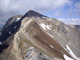
The Campbieil is a summit in the French Pyrenees, culminating at a height of 3,173 m (10,410 ft). It is located in the Néouvielle massif, included in the Pyrenees National Park of which it constitutes the second highest summit, after the pic Long (3,192 m (10,472 ft)).
Contents
Map of Campbieil, 65170 Aragnouet, France
History
The first recorded ascension dates from 1848, by captain Loupot who was carrying out triangulation works. Of very easy access by its western slope, that of Gèdre, the summit is frequented by sheep and isards and has ever been ambled by shepherds and hunters.
Access
The most frequented access route runs today through the north, by a path which presents no difficulty (besides its steepness), from the Cap de Long dam.
Another slightly shorter route, is accessible to the east : which consists in reaching the Estaragne by ascending the stream hollow of Estaragne from the D 929, then to walk along the crest. It too, presents no major difficulty, at least not on a clear summer day.