
County Hamilton FIPS code 39-11150 Elevation 176 m Zip code 45111 Local time Tuesday 6:58 AM | State Ohio Time zone Eastern (EST) (UTC-5) GNIS feature ID 1056758 Area 100 ha Population 375 (2010) | |
 | ||
Weather 13°C, Wind S at 26 km/h, 86% Humidity | ||
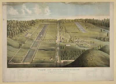
Camp Dennison is a census-designated place (CDP) just outside Indian Hill in southern Symmes Township, Hamilton County, Ohio, United States. Although it is unincorporated, it has a post office, with the ZIP code of 45111. The population was 375 at the 2010 census. During the American Civil War, Camp Dennison served as a military recruiting and training post for the United States Army (see Camp Dennison). It is named for William Dennison, the 24th Governor of Ohio and U.S. Postmaster General under President Abraham Lincoln.
Contents
Map of Camp Dennison, OH 45111, USA
The community was settled in 1796 by German immigrants.
Geography
Camp Dennison is located at 39°11′53″N 84°17′19″W in the valley of the Little Miami River, 17 miles (27 km) northeast of downtown Cincinnati. Ohio State Route 126, Glendale Milford Road, runs north-south through the center of the community.
According to the United States Census Bureau, the CDP has a total area of 0.39 square miles (1.0 km2), all land.