Trisha Shetty (Editor)

Caloundra (suburb)

Updated on
Edit
Like
Comment
Share on FacebookTweet on TwitterShare on LinkedInShare on Reddit
Population
  
3,558 (2011 census)

LGA(s)
  
Sunshine Coast Region

State electorate(s)
  
Caloundra

Postal code
  
4551

Federal division
  
Division of Fisher

Postcode(s)
  
4551

County
  
Canning

Area
  
3.9 km²

Parish
  
Bribie Island

Caloundra (suburb) httpsuploadwikimediaorgwikipediacommonsthu

Location
  
90 km (56 mi) N of Brisbane 19 km (12 mi) E of Landsborough

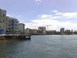
Caloundra is a suburb of the Sunshine Coast, Queensland, Australia, and includes the central business district of the Caloundra urban centre, which is located on Bulcock Street. At the 2011 Australian Census the suburb recorded a population of 3,558.

Contents

Heritage listings

The suburb of Caloundra has a number of heritage-listed sites, including:

  • Bowman Road: Tripcony Hibiscus Caravan Park
  • Education

    Caloundra contains the following schools within its boundaries:

  • Caloundra State School (1889)
  • Caloundra State High School (1967)
  • Caloundra Christian College (1983)
  • Caloundra is also home to a campus of the Sunshine Coast Institute of TAFE.

    Shopping

  • Stockland Caloundra
  • Caloundra Village Shopping Centre
  • Parks and recreation

  • Bulcock Beach (patrolled by Ithaca–Caloundra City Life Saving Club) and Clarke Place Park
  • Central Park (includes Caloundra Tennis Centre, which hosts the Caloundra International)
  • Ben Bennett Botanical Park
  • Bicentennial Park
  • Lighthouse Park
  • Roy Henzell Park
  • Other facilities

  • Caloundra Hospital
  • Caloundra bus station
  • Caloundra Golf Club
  • Council service centre for Sunshine Coast Region
  • A range of accommodation from backpackers to resort hotels
  • References

    Caloundra (suburb) Wikipedia