
Time zone Pacific (PST) (UTC-8) Elevation -54.9 m Zip code 92233 Local time Monday 10:24 AM | Incorporated February 28, 1919 Area codes 442/760 Area 9.624 km² Population 7,095 (2013) Number of airports 1 | |
 | ||
Weather 17°C, Wind N at 10 km/h, 29% Humidity | ||
Calipatria (formerly, Date City) is a city in Imperial County, California. Calipatria is located 23 miles (37 km) north of El Centro, It is part of the El Centro Metropolitan Area. The population was 7,710 at the 2010 census, up from 7,289 at the 2000 census, including 4000 inmates at Calipatria State Prison. The community is located along State Route 111.
Contents
- Map of Calipatria CA 92233 USA
- Geography
- Climate
- History
- 2010
- 2000
- Politics
- Landmarks
- Sister cities
- References
Map of Calipatria, CA 92233, USA
Geography
Calipatria is located at 33°07′32″N 115°30′51″W.
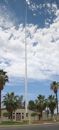
At an elevation of 180 feet (55 m) below sea level, Calipatria is the lowest elevation city in the western hemisphere. The city currently claims to have the "tallest flagpole (184 feet) where the flag flies at sea level" at 184 feet (56 m), so their American flag will always fly above sea level. According to the Guinness Book of World Records the Jeddah Flagpole holds the title of world's tallest, but it is entirely above sea level.
According to the United States Census Bureau, the city has a total area of 3.7 square miles (9.6 km2), all land.
Climate
This area has a large amount of sunshine year round due to its stable descending air and high pressure. According to the Köppen Climate Classification system, Calipatria has a hot desert climate, abbreviated "Bwh" on climate maps.
History
The Imperial Valley Farm Lands Association founded the town as Date City in 1914. The first post office at Calipatria opened in 1914. Calipatria incorporated in 1919.
2010
The 2010 United States Census reported that Calipatria had a population of 7,800. The population density was 2,073.6 people per square mile (800.6/km²). The racial makeup of Calipatria was 3,212 (41.7%) White, 1,612 (20.9%) African American, 80 (1.0%) Native American, 95 (1.2%) Asian, 25 (0.3%) Pacific Islander, 2,455 (31.9%) from other races, and 227 (2.9%) from two or more races. Hispanic or Latino of any race were 4,940 persons (64.1%).
The Census reported that 3,541 people (46.0% of the population) lived in households, 0 (0%) lived in non-institutionalized group quarters, and 4,164 (54.0%) were institutionalized.
There were 1,008 households, out of which 541 (53.7%) had children under the age of 18 living in them, 515 (51.0%) were opposite-sex married couples living together, 213 (21.1%) had a female householder with no husband present, 92 (9.1%) had a male householder with no wife present. There were 53 (5.3%) unmarried opposite-sex partnerships, and 15 (1.5%) same-sex married couples or partnerships. 162 households (16.1%) were made up of individuals and 70 (6.9%) had someone living alone who was 65 years of age or older. The average household size was 3.51. There were 819 families (81.3% of all households); the average family size was 3.92.
The population was spread out with 1,246 people (16.2%) under the age of 18, 932 people (12.1%) aged 18 to 24, 3,738 people (48.5%) aged 25 to 44, 1,431 people (18.6%) aged 45 to 64, and 358 people (4.6%) who were 65 years of age or older. The median age was 32.9 years. For every 100 females there were 330.9 males. For every 100 females age 18 and over, there were 427.3 males.
There were 1,121 housing units at an average density of 301.7 per square mile (116.5/km²), of which 536 (53.2%) were owner-occupied, and 472 (46.8%) were occupied by renters. The homeowner vacancy rate was 5.9%; the rental vacancy rate was 10.6%. 1,867 people (24.2% of the population) lived in owner-occupied housing units and 1,674 people (21.7%) lived in rental housing units.
2000
As of the census of 2000, there were 7,289 people, 899 households, and 756 families residing in the city. The population density was 1,965.8 people per square mile (758.6/km²). There were 961 housing units at an average density of 259.2 per square mile (100.0/km²). The racial makeup of the city was 32.4% White, 21.3% Black or African American, 0.7% Native American, 0.6% Asian, <0.1% Pacific Islander, 42.7% from other races, and 2.3% from two or more races. 57.4% of the population were Hispanic or Latino of any race.
There were 899 households out of which 50.4% had children under the age of 18 living with them, 61.2% were married couples living together, 17.6% had a female householder with no husband present, and 15.8% were non-families. 14.1% of all households were made up of individuals and 5.6% had someone living alone who was 65 years of age or older. The average household size was 3.6 and the average family size was 3.9.
In the city, the population was spread out with 16.3% under the age of 18, 12.3% from 18 to 24, 52.6% from 25 to 44, 15.0% from 45 to 64, and 3.8% who were 65 years of age or older. The median age was 33 years. For every 100 females there were 363.4 males. For every 100 females age 18 and over, there were 497.5 males.
The median income for a household in the city was $60,962, and the median income for a family was $61,302. Males had a median income of $61,350 versus $50,063 for females. The per capita income for the city was $43,970. About 2.4% of families and 2.4% of the population were below the poverty line, including 28.9% of those under age 18 and 17.8% of those age 65 or over.
Calipatria is one of the state's poorest cities in income per capita due to agricultural paychecks and a declined economy in the 1990s. Hispanics mostly of Mexican descent are three-fourths of the people (excluding the multiracial body of state prison convicts). The city was first called Sante Patria (as in "Saint of the Motherland") and was founded by Irish American and Irish Mexican soldiers, who deserted both in the Mexican–American War (1850's) and from the Union and/or Confederate armies after the American Civil War (1860's) but Calipatria also has a large Arab population from Jordan, Lebanon and Syria, descendants of agriculture laborers in the 1920s.
Politics
In the state legislature, Calipatria is in the 40th Senate District, represented by Democrat Ben Hueso, and the 56th Assembly District, represented by Democrat Eduardo Garcia.
Federally, Calipatria is in California's 51st congressional district, represented by Democrat Juan Vargas.
Landmarks
Salvation Mountain is a notable tourist attraction in the north of Calipatria, near Slab City. Salvation Mountain is a small hill which is entirely covered in thousands of gallons of acrylic paint, straw, concrete, adobe. It was created by Leonard Knight to convey the message that "God Loves Everyone". Salvation Mountain was featured in the book Into the Wild and also in the 2007 movie of the same name. The video for Fourth of July by Shooter Jennings, is partially set at Salvation Mountain.