
Counties: San Luis Obispo | Length 14.48 km | |
 | ||
County | ||
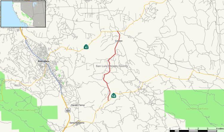
State Route 229 (SR 229) is a short state highway in the U.S. state of California. The route runs from State Route 58 to State Route 41. It connects the small town of Creston with the rural state routes. Also, in conjunction with SR 58 and SR 41, it provides a slower, more scenic route between the Central Coast and the San Joaquin Valley.
Contents
Map of CA-229, Creston, CA 93432, USA
Route description
SR 229 starts at SR 58 east of Santa Margarita. It travels north on Webster Road as a one-lane, windy mountain road, after which the road widens to two lanes as it approaches Rocky Canyon Road. In this segment, it is a county road much like a standard rural state route. It continues north through relatively flat, rural farmland and then passes through the small town of Creston, continuing north and terminating at SR 41. As of July 2013, it has been recently chip sealed and is a little greasy in the extreme heat, but still an above average road surface, with quite a few gut check drops and rises in the apexes of the many quick curves.
History
SR 229 was adopted as a state route in 1933 as Legislative Route 137. It was an unsigned highway running from LRN 2 (currently US 101) near Santa Margarita to LRN 125 (formally US 466, currently SR 41). Its original purpose was to provide an alternate route between US 101 (the major north-south route on the Central Coast) to US 466 (a major route connecting the Central Coast to the San Joaquin Valley). In the 1950s, US 466 was moved to LRN 33 (currently SR 46). The original alignment became unsigned. In 1957, LRN 137 was changed to start at LRN 58 (currently SR 58) instead of LRN 2. This isolated the route between two rural routes. In 1964, with the renumbering of California state routes, LRN 137 became SR 229 and became a signed route. It has changed little since that time.
Major intersections
Except where prefixed with a letter, postmiles were measured on the road as it was in 1964, based on the alignment that existed at the time, and do not necessarily reflect current mileage. R reflects a realignment in the route since then, M indicates a second realignment, L refers an overlap due to a correction or change, and T indicates postmiles classified as temporary (for a full list of prefixes, see the list of postmile definitions). Segments that remain unconstructed or have been relinquished to local control may be omitted. The entire route is in San Luis Obispo County.