
Counties: Kern | Length 10.88 km | |
 | ||
Existed: 1933 as LRN 141,1964 as SR 204 – present | ||
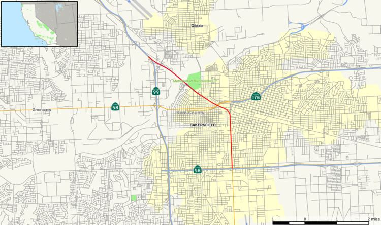
State Route 204 is a short state highway in the Bakersfield, California, United States area. It connects SR 99 and SR 58 with downtown. It also connects Bakersfield's three major freeways together (SR 99, SR 58, and SR 178). Only the north 1.4 miles has been built to freeway standards; the rest is a six-lane arterial road.
Contents
Map of CA-204, Bakersfield, CA, USA
All of SR 204 is a part of State Route 99 Business. The business route also continues south, where it meets with SR 99.
Route description
SR 204 begins as a six-lane arterial at SR 58 as Union Avenue. From there, the route travels north on Union Avenue. After intersecting California Avenue., SR 204 crosses underneath the Truxtun Avenue interchange. At the Union Avenue. Y intersection, the route turns northwest as Golden State Avenue. It then crosses SR 178 and Garces Circle, which provides access to Downtown Bakersfield. The route then crosses F St, at which point it becomes a four-lane freeway. The route crosses its only numbered interchange at Airport Dr, and then terminates at SR 99.
History
Before the 1964 renumbering, State Route 204 was known as Legislative Route 141. It was created in 1933 as a western bypass to Bakersfield via Brundage Lane. and Oak St. At that time, US 99 (defined by the State as Legislative Route 4) ran through Bakersfield via Chester Ave, and through Oildale (north of Bakersfield) via Roberts Ln. LRN 141 started at the intersection of US 99 (Chester Ave.) and Brundage Ln, where it traveled west to Oak St. At Oak St, the route turned north, crossed the Kern River, and terminated at US 99 (Roberts Ln.) near Beardsley School in Oildale.
In the mid 1930s US 99 was moved from Chester Ave./Roberts Ln. to Union Ave./Golden State Ave. During the late 1950s, the Union Ave. Wye, Truxton Ave. Interchange, and Chester Ave. Interchange (with the bridge over Garces Circle) were constructed to improve traffic flow. However, when the US 99 freeway bypass was constructed in 1963, Caltrans decided to use the Oak St. route around the city instead of the Union Ave. route through the city. As a result, the route designations were swapped. The freeway parallel to Oak St. would become US 99. LRN 141 would become the US 99 bypass via Brundage Ln, Union Ave, and Golden State Ave. That designation never took effect because in 1963 all of the state highways were renumbered. As a result, LRN 141 became SR 204. Its definition was also simplified to bypass SR 99 via Union Ave. and Golden State Ave, although that change lengthened the route. In 1978, the route was shortened to connect SR 58 to SR 99 via Union Ave. and Golden State Ave, which was close to the original 1963 definition.
Future
Bakersfield has considered several times to convert all or part of SR 204 to a freeway. In 1986, part of the route was considered as the western extension of SR 178. However, that study (which was not a formal route adoption study) recommended another alignment for the freeway. In 2001, Bakersfield’s system study proposed converting all of SR 204 to a freeway as part of the western extension of SR 58. However, that proposal has been dropped in favor of the Westside Parkway connection (known as the Centennial Corridor).
Major intersections
Except where prefixed with a letter, postmiles were measured on the road as it was in 1964, based on the alignment that existed at the time, and do not necessarily reflect current mileage. R reflects a realignment in the route since then, M indicates a second realignment, L refers an overlap due to a correction or change, and T indicates postmiles classified as temporary (for a full list of prefixes, see the list of postmile definitions). Segments that remain unconstructed or have been relinquished to local control may be omitted. The entire route is in Bakersfield, Kern County.