
West end: SR 1 in Venice | Length 8.698 km | |
 | ||
Major cities | ||
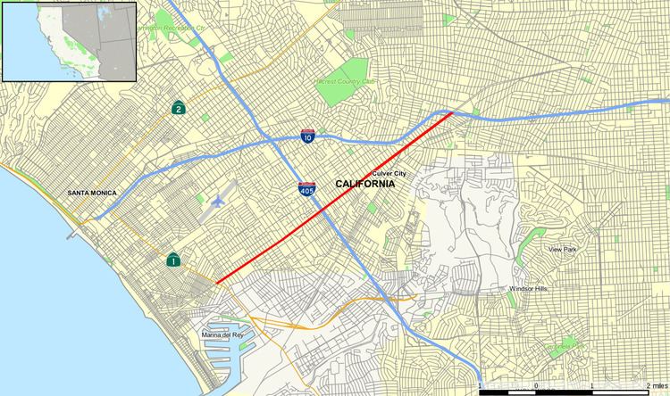
California State Route 187 (SR 187) in Los Angeles is the portion of Venice Boulevard between Lincoln Boulevard (State Route 1) in Venice and its intersection with Interstate 10 in the South Robertson district.
Contents
Map of CA-187, Los Angeles, CA, USA
Route description
Proceeding easterly, Venice Boulevard assumes the designation California State Route 187 at Lincoln Boulevard (State Route 1). The route then passes through the Mar Vista neighborhood. Further east, it briefly forms the boundary between Palms and Culver City and passes near Sony Pictures Studios. Continuing northeast into the South Robertson neighborhood of Los Angeles, the SR 187 designation terminates at the intersection with Cadillac Avenue and the ramp carrying traffic from westbound I-10.
History
Route 163 was defined in 1961 as a route from the ocean in Santa Monica to Route 173, routed along Pacific Avenue and Venice Boulevard. This was redefined as SR 187 in the 1964 state highway renumbering. In 1988, the part of SR 187 in Santa Monica was removed from the state highway system. The part of the route from the southern boundary of Santa Monica to Lincoln Boulevard was removed in 1994.
Future
According to Section 487 of the California Streets and Highways Code, the entire length of Route 187 is eligible for relinquishment to the City of Los Angeles. If a relinquishment occurs, the state highway will cease to exist.
Major intersections
Except where prefixed with a letter, postmiles were measured on the road as it was in 1964, based on the alignment that existed at the time, and do not necessarily reflect current mileage. R reflects a realignment in the route since then, M indicates a second realignment, L refers an overlap due to a correction or change, and T indicates postmiles classified as temporary (for a full list of prefixes, see the list of postmile definitions). Segments that remain unconstructed or have been relinquished to local control may be omitted. The entire route is in Los Angeles, Los Angeles County.