
Length 40.14 km | ||
 | ||
County | ||
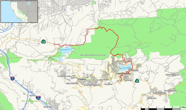
State Route 173 (SR 173) runs from State Route 138 near the west end of Silverwood Lake in the Summit Valley south of Hesperia to State Route 18 south of Lake Arrowhead, United States. It is the only California state highway with an unpaved segment, which is a one-lane jeep trail on the Northwestern face of the San Bernardino Mountains directly east of Summit Valley and northwest of Blue Jay. The route starts at the Mojave River Forks, skims the easterly and southerly sides of Lake Arrowhead and meets State Route 189, Lake's Edge Road, at the south entrance to the Lake Arrowhead mall. The route runs entirely in San Bernardino County, mostly in the San Bernardino National Forest.
Contents
Map of CA-173, California, USA
Since March 2011, the one-lane unpaved segment of SR 173 has been closed from Hesperia to Lake Arrowhead. Through traffic should use SR 138 and SR 18. An alternate route from Hesperia to Lake Arrowhead would involve heading south on I-15, then east on SR 210 in San Bernardino to reach the southern terminus of SR 18 at Waterman Road.
Route description
SR 173 is eligible for inclusion in the State Scenic Highway System. However, it has not been designated by Caltrans as a scenic highway.
SR 173 begins at SR 138 just inside the Hesperia city limits and travels east along the shore of Silverwood Lake, passing near Cedar Springs Dam. The road briefly turns north further into the Hesperia city limits, leaving the San Bernardino National Forest. SR 173 leaves the city and enters Mojave River Forks Regional Park, where it turns east and intersects Arrowhead Lake Road, which leads to the urban center of Hesperia. Once SR 173 intersects the Pacific Crest National Scenic Trail, it turns into a one-lane dirt road rising along the north face of the San Bernardino Mountains, first heading east to its apex before turning south to the Lake Arrowhead area. A few miles from Lake Arrowhead, SR 173 becomes paved and enters the community of Cedar Glen, where it parallels the Lake Arrowhead shoreline and encounters Papoose Lake. The highway enters the community of Lake Arrowhead, where SR 173 intersects SR 189 and turns south to terminate at SR 18.
History
Before 1964, Route 173 was part of California Legislative Route 59; however, like a small number of other California State highways, it was not signed. From 1934 to the mid-1950s the part of Route 59 that is now Route 173 was designated by the California Division of Highways to be a segment of California sign route 2; however, signing did not occur. From the mid-1950s through July 1964, the Division of Highways changed the routing of future sign route 2 from the subject segment of Route 59 to Legislative Route 188, the segment of present California 138 between the junction of Routes 138 and 173 and Mount Anderson Junction, the junction of Routes 18 and 138 south of Crestline.
The highway has faced repeated problems since the 2003 Willow Fire that has made the one-lane unpaved trail portion (between Postmile 7 and Postmile 11) unsafe for passage from erosion and storm damage. As of March 2011, the one-lane trail portion of SR 173 is permanently closed to through traffic. While roadway preservation maintenance (basic grading, debris clearance) is still done, this decision effectively ends all further interest to upgrade the segment to a 2-lane passable highway through state-funded projects.
Major intersections
Except where prefixed with a letter, postmiles were measured on the road as it was in 1964, based on the alignment that existed at the time, and do not necessarily reflect current mileage. R reflects a realignment in the route since then, M indicates a second realignment, L refers an overlap due to a correction or change, and T indicates postmiles classified as temporary (for a full list of prefixes, see the list of postmile definitions). Segments that remain unconstructed or have been relinquished to local control may be omitted. The entire route is in San Bernardino County.