
Length 34.02 km | ||
 | ||
County | ||
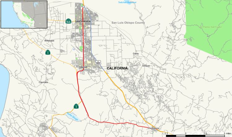
State Route 135 is a state highway in the U.S. state of California, entirely within Santa Barbara County, and is basically a bypass of U.S. Route 101 in northern Santa Barbara County between the town of Los Alamos and the city of Santa Maria.
Contents
Map of CA-135, Santa Maria, CA, USA
Route description
SR 135 starts off as Bell Street in Los Alamos and goes along with Vandenberg Road after an intersection with Harris Grade Road before merging with State Route 1 south of Orcutt. There is a brief freeway portion at the northern split of SR 135 and SR 1, but it quickly reverts to a city street upon crossing Clark Avenue. North of Santa Maria Way, it is considered Business US 101, although signage is poor. SR 135 continues its northbound journey as Broadway and passes through the Santa Maria Town Center shopping center at the intersection with Main Street (State Route 166). SR 135 meets US 101 again just before crossing the Santa Maria River at the Santa Barbara/San Luis Obispo county line.
History
State Route 135 is the original routing for US 101 from Santa Maria to Los Alamos until the current alignment was completed in 1933. But instead of turning east just before old town Orcutt and then north into Santa Maria as it does currently, it continued north along what is now Graciosa road and then Marcum Street linking up with E. Clark Avenue just north of the Orcutt water tower. It then followed Clark Avenue east through old Orcutt and turned north on Orcutt Road at the location of the current Highway 135/Clark Avenue interchange and headed north through Santa Maria.
Route 135 was created in 1964 to encompass most of the old routing.
Major intersections
Except where prefixed with a letter, postmiles were measured on the road as it was in 1964, based on the alignment that existed at the time, and do not necessarily reflect current mileage. R reflects a realignment in the route since then, M indicates a second realignment, L refers an overlap due to a correction or change, and T indicates postmiles classified as temporary (for a full list of prefixes, see the list of postmile definitions). Segments that remain unconstructed or have been relinquished to local control may be omitted. The entire route is in Santa Barbara County.