
 | ||
World ocean circulation california current
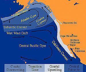
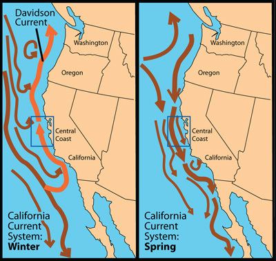
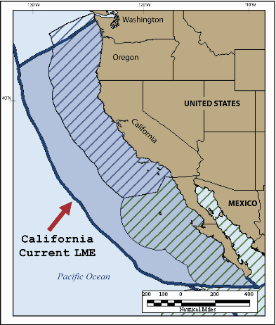
The California Current is a Pacific Ocean current that moves southward along the western coast of North America, beginning off southern British Columbia and ending off southern Baja California Peninsula. It is considered an Eastern boundary current due to the influence of the North American coastline on its course. It is also one of five major coastal currents affiliated with upwelling zones, the others being the Humboldt Current, the Canary Current, the Benguela Current, and the Somali Current. The California Current is part of the North Pacific Gyre, a large swirling current that occupies the northern basin of the Pacific.
Contents
- World ocean circulation california current
- Physical properties
- Biological properties
- Related Currents
- In popular culture
- References
Physical properties
The movement of northern waters southward results in coastal waters cooler than coastal areas of comparable latitude on the east coast of the United States, along with cool summer air temperatures for the immediate coastline areas. For example, Half Moon Bay at 37 degrees latitude has no month with an average high above 67 °F (19 °C) and San Francisco often stays below 70 °F (21 °C) in summer. Additionally, extensive upwelling of colder sub-surface waters occurs, caused by the prevailing northwesterly winds acting through the Ekman Effect. The winds drive surface water to the right of the wind flow, that is offshore, which draws water up from below to replace it. The upwelling further cools the already cool California Current. This is the mechanism that produces California's characteristic coastal fog and the negative temperature anomaly measured in California's coastal waters during summer. This translates into cold coastal waters during the summer, stretching from Oregon to Baja California. This does not include the coastal water surrounding San Diego, where a warm water anomaly occurs.
The cold water is highly productive due to the upwelling, which brings to the surface nutrient-rich sediments, supporting large populations of whales, seabirds and important fisheries. Winds of the appropriate direction and strength to induce upwelling are more prevalent in the presence of Eastern boundary currents, such as the California Current. Phytoplankton production is dramatically increased in these areas because the nutrient-rich water lying below the pycnocline is relatively close to the surface and is thus easily upwelled. Scientists at Scripps Institution of Oceanography said in 2011 that the average surface temperature of the water at Scripps Pier has increased by almost 3 degrees since 1950.
Bakun (1973) calculated a 20-year average of the monthly mean Ekman transport for different regions off the California coast. His "Bakun upwelling index" ranges from 300 meters-cubed/second (in the offshore direction) to −212 meters-cubed/second (toward the coast, or onshore direction). Bakun's index showed there is year-round upwelling off Southern California's coast, but it is strongest in the summer months. Bakun's work also shows that off the coast of Oregon and Washington, there is forceful downwelling in the winter months, and upwelling in the region is restricted to the months of April through September.
Biological properties
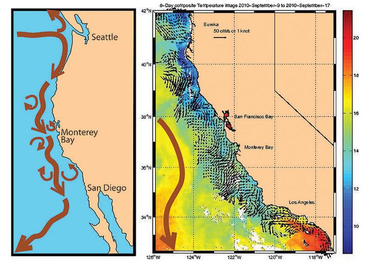
Primary production is a topic of interest among those who study the California Current. In their study, Hayward and Venrick (1982) found great variability in both biomass and the productivity of phytoplankton in the California Current. The differences observed by Hayward and Venrick in carbon-fixation rates (0.2–2.0 grams carbon/(meter-squared × day)) show the heterogeneous nature of the California Current, with its combination of advected (see advection) and upwelled water. Several studies have investigated the carbon flow from primary production to the pelagic fish stocks which depend on the California Current. Lasker (1988) described powerful "jets and squirts" off northern and central California. These 'jets and squirts' move large quantities of cold, nutrient rich water offshore. This water then gets carried by the southward bound California Current and adds significant primary production to the sardine population.
Related Currents
A narrower, weaker counter current, the Davidson Current, occasionally moves somewhat warmer water northwards during the winter months. During El Niño events, the California Current is disrupted, leading to declines in phytoplankton, resulting in cascading effects up the food chain, such as declines in fisheries, seabird breeding failures and marine mammal mortality (Schwing et al., 2003). In 2005, a failure in the otherwise predictable upwelling events, unassociated with El Niño, caused a collapse in krill in the current, leading to similar effects (Schwing et al., 2003).
The Southern California Bight is a sub-region of the California Current and has unique physical properties. Upwelling is fairly weak in the California Bight and Smith and Eppley (1982) stated that the 16-year average for primary production was 0.402 grams carbon/(meter-squared × day), or approximately 150 grams carbon/(meter-squared × year). Further, Smith and Eppley (1982) found that the highest daily rates of temperature decrease were correlated with the maximum amount of upwelling. Digiacomo and Holt (2001) used satellite images to study the mesoscale and sub-mesoscale eddies in the Southern California Bight. Their work showed that all eddies were less than 50 km in diameter and 70% of all eddies measured less than 10 km. The eddies appeared to be caused mostly by topography (particularly islands), wind, and instabilities in the current. The location of these eddies was mainly between the California Current (flowing toward the equator) and the coastline. The majority of these eddies were cyclonic and had the ability to induce the upwelling of nutrient-rich water. Small scale topographic features such as headlands have been shown to cause substantial effects on the population dynamics of benthic invertebrates, such a change in the settlement patterns of crabs and sea urchin.
In popular culture
In the 2016 Disney/Pixar animated film Finding Dory, the CC is portrayed as a superhighway that fish and sea turtles use to travel to California . The characters Marlin, Nemo, and Dory join a group of sea turtles in using the CC and the EAC to help them travel to Morro Bay, California.