
Founded March 5, 1856 Congressional district 2nd Area 727.8 km² Population 7,564 (2013) | Largest city Grantsville Cities Grantsville | |
 | ||
Website www.calhouncounty.wv.gov Rivers Little Kanawha River, Bear Fork, Trace Fork, Walker Creek | ||
Calhoun County is a county in the U.S. state of West Virginia. As of the 2010 census, the population was 7,627. Its county seat is Grantsville. The county was founded in 1856 and named for South Carolina politician John C. Calhoun.
Contents
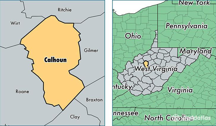
- Map of Calhoun County WV USA
- Geography
- Major highways
- Adjacent counties
- 2010 census
- 2000 census
- Attractions
- Town
- References
Map of Calhoun County, WV, USA
Geography
According to the U.S. Census Bureau, the county has a total area of 281 square miles (730 km2), of which 279 square miles (720 km2) is land and 1.4 square miles (3.6 km2) (0.5%) is water.
Major highways
Adjacent counties
2010 census
As of the 2010 United States Census, there were 7,627 people, 3,268 households, and 2,178 families residing in the county. The population density was 27.3 inhabitants per square mile (10.5/km2). There were 3,963 housing units at an average density of 14.2 per square mile (5.5/km2). The racial makeup of the county was 98.4% white, 0.3% American Indian, 0.2% black or African American, 0.2% Asian, 0.2% from other races, and 0.7% from two or more races. Those of Hispanic or Latino origin made up 0.7% of the population. In terms of ancestry, 22.4% were German, 21.3% were Irish, 7.7% were American, 7.3% were English, and 5.7% were Dutch.
Of the 3,268 households, 26.5% had children under the age of 18 living with them, 51.7% were married couples living together, 9.7% had a female householder with no husband present, 33.4% were non-families, and 28.5% of all households were made up of individuals. The average household size was 2.33 and the average family size was 2.80. The median age was 45.1 years.
The median income for a household in the county was $26,922 and the median income for a family was $34,897. Males had a median income of $32,229 versus $20,707 for females. The per capita income for the county was $17,121. About 13.2% of families and 20.5% of the population were below the poverty line, including 35.0% of those under age 18 and 6.6% of those age 65 or over.
2000 census
As of the census of 2000, there were 7,582 people, 3,071 households, and 2,201 families residing in the county. The population density was 27 people per square mile (10/km²). There were 3,848 housing units at an average density of 14 per square mile (5/km²). The racial makeup of the county was 98.91% White, 0.11% Black or African American, 0.30% Native American, 0.11% Asian, 0.01% Pacific Islander, 0.13% from other races, and 0.44% from two or more races. 0.55% of the population were Hispanic or Latino of any race.
There were 3,071 households out of which 28.90% had children under the age of 18 living with them, 57.00% were married couples living together, 10.30% had a female householder with no husband present, and 28.30% were non-families. 24.90% of all households were made up of individuals and 12.30% had someone living alone who was 65 years of age or older. The average household size was 2.46 and the average family size was 2.91.
In the county, the population was spread out with 22.40% under the age of 18, 8.00% from 18 to 24, 25.90% from 25 to 44, 27.10% from 45 to 64, and 16.70% who were 65 years of age or older. The median age was 41 years. For every 100 females there were 99.70 males. For every 100 females age 18 and over, there were 98.30 males.
The median income for a household in the county was $21,578, and the median income for a family was $26,701. Males had a median income of $25,609 versus $14,304 for females. The per capita income for the county was $11,491. About 19.10% of families and 25.10% of the population were below the poverty line, including 29.40% of those under age 18 and 24.90% of those age 65 or over.
Attractions
Calhoun County is home to four public parks: The Upper West Fork Park in Chloe on West Virginia Route 16, the West Fork Park in Arnoldsburg on U.S. Route 33, Mt. Zion Park on West Virginia Route 16, and Calhoun County Park on West Virginia Route 16.
Calhoun is home to the annual Ramp Festival in April, the West Virginia Wood Festival in June, the Bluegrass Festival in May, another Bluegrass Festival in August, the West Virginia Molasses Festival in September, and Octoberfest Celebration. Also, the Hometown Country Christmas Craft show is sponsored by and held in the county court house the first week of December.
Calhoun County is home to one of the last 500 drive-in theaters in the nation, Mt. Zion Drive In. Calhoun also has one of the largest genealogy collections in the state, housed at Calhoun County Library. The library is also home to the "West Virginia Room" which includes books on West Virginia and by West Virginians.