
Founded 1848 Area 1,417 km² | Website co.caldwell.tx.us Population 39,232 (2013) Unemployment rate 3.7% (Apr 2015) | |
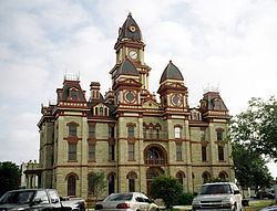 | ||
Points of interest Caldwell County Courthouse, Lockhart State Park, Caldwell County Museum, Luling Area Oil Museum, Southwest Museum of Clocks | ||
Top move in ready virtual home tour video for sale in caldwell county texas on land
Caldwell County is a county located in the U.S. state of Texas. As of the 2010 census, the population was 38,066. Its county seat is Lockhart. The county was founded in 1848 and was named after Mathew Caldwell, a ranger captain who fought in the Battle of Plum Creek against the Comanches and against Santa Anna's armies during the Texas Revolution. Caldwell was also a signer of the Texas Declaration of Independence.
Contents
- Top move in ready virtual home tour video for sale in caldwell county texas on land
- Map of Caldwell County TX USA
- History
- Geography
- Major highways
- Adjacent counties
- Demographics
- Cities
- Unincorporated communities
- Ghost Town
- References
Map of Caldwell County, TX, USA
Caldwell County is part of the Greater Austin metropolitan area.
History
Geography
According to the U.S. Census Bureau, the county has a total area of 547 square miles (1,420 km2), of which 545 square miles (1,410 km2) is land and 1.9 square miles (4.9 km2) (0.3%) is water.
Major highways
Adjacent counties
Demographics
As of the 2010 United States Census, there were 38,066 people residing in the county. 75.8% were White, 6.8% Black or African, 0.9% Asian, 0.8% Native American, 13.1% of some other race and 2.5% of two or more races. 47.1% were Hispanic or Latino (of any race).
As of the census of 2000, there were 32,194 people, 10,816 households, and 8,079 families residing in the county. The population density was 59 people per square mile (23/km²). There were 11,901 housing units at an average density of 22 per square mile (8/km²). The racial makeup of the county was 70.13% White, 8.50% Black or African American, 0.61% Native American, 0.34% Asian, 0.03% Pacific Islander, 17.66% from other races, and 2.74% from two or more races. 40.44% of the population were Hispanic or Latino of any race.
There were 10,816 households out of which 37.00% had children under the age of 18 living with them, 56.00% were married couples living together, 13.30% had a female householder with no husband present, and 25.30% were non-families. 21.20% of all households were made up of individuals and 9.40% had someone living alone who was 65 years of age or older. The average household size was 2.82 and the average family size was 3.28.
A Williams Institute analysis of 2010 census data found there were about 5.8 same-sex couples per 1,000 households in the county.
In the county, the population was spread out with 28.30% under the age of 18, 8.50% from 18 to 24, 29.80% from 25 to 44, 20.80% from 45 to 64, and 12.50% who were 65 years of age or older. The median age was 34 years. For every 100 females there were 97.50 males. For every 100 females age 18 and over, there were 92.70 males.
The median income for a household in the county was $36,573, and the median income for a family was $41,300. Males had a median income of $29,295 versus $21,595 for females. The per capita income for the county was $15,099. About 10.40% of families and 13.10% of the population were below the poverty line, including 15.10% of those under age 18 and 15.40% of those age 65 or over.