
OS grid reference SM 7617 2425 Country Wales Postcode district SA62 | Sovereign state United Kingdom Police Dyfed-Powys Post town Haverfordwest | |
 | ||
Similar | ||
Double rainbow caerfai bay pembrokeshire st davids
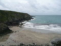
Caerfai Bay near St Davids in Pembrokeshire West Wales has cliffs of purple sandstone and a sandy beach at low tide reached by steep steps. There is free parking above the beach with picnic benches and views of the islands of Skomer and Skokholm.
Contents
- Double rainbow caerfai bay pembrokeshire st davids
- Map of Caerfai Bay Haverfordwest UK
- Geology
- Location
- Caerfai Farm
- References
Map of Caerfai Bay, Haverfordwest, UK
Geology
The cliffs have distinctive red sandstone of the type used for building St Davids Cathedral.
Location
Caerfai is the closest beach 1.5 miles (2.4 km) from the cathedral city of St Davids and can be reached by the Pembrokeshire Coast Path. Nearby is the Chapel of St Non which is the most westerly in Wales.
Caerfai Farm
Caerfai Farm is 140 acres (0.57 km2) producing organic milk, cheeses, potatoes, pigs, beef and cereals using sustainable energy sources, including solar, geothermal, wind and biomass energy. The farm also has a shop and a campsite.