
Use Hiking, Backpacking | ||
 | ||
Trailheads Palm Springs Art MuseumSan Jacinto Peak. Trail difficulty Very strenuous, difficult to follow, temperature extremes, no water Address Skyline Trail, Palm Springs, CA 92262, USA | ||
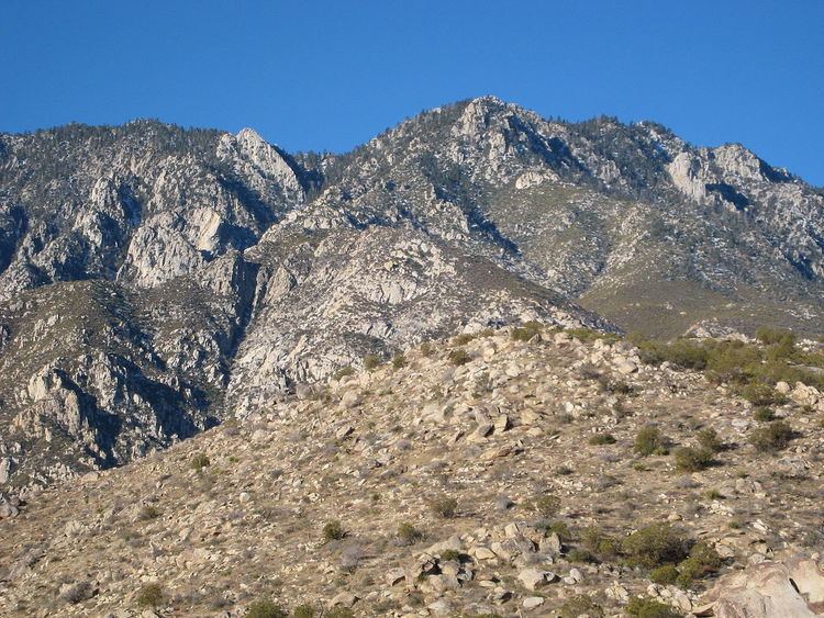
The Cactus to Clouds Trail from Palm Springs, California, to San Jacinto Peak is a hiking trail. With a net elevation gain of 10,300 feet (3,100 m), it has the greatest elevation increase of any day-hike route in the United States. It gains it in only 14 miles (23 km), also making it one of the steeper trails of its length in the world. Also known as the Skyline Trail, it climbs 7,900 feet from the desert to Long Valley where it joins with the main trail to gain another 2,400 feet to the summit. The trail is ten miles to the tram in Long Valley (coined nickname Cactus to Crowds) or twenty miles to San Jacinto Peak and back down to the tram.
Contents
The trail starts behind the Palm Springs Art Museum. The bottom portion, known as the Museum Trail, continues to a junction with the North Lykken Trail. At its end it joins the Desert View Nature Trail. Hikers may proceed to Long Valley and then continue to the Palm Springs Aerial Tramway or San Jacinto Peak. (The Palm Springs Aerial Tramway was closed for annual maintenance Sept. 12 - Sept. 30, 2016 and re-opened Oct. 1, 2016.)
With the exception of the final few miles to the summit, no portion of the Skyline Trail is an officially sanctioned trail of any public land agency; however, public access to the area is allowed. It is recognized as a cross-country route by most authorities. It is maintained by local hikers, who have painted directions onto rocks and maintain two emergency water caches.
History
Ray Wilson and Sue Birnbaum, former Coachella Valley Hiking Club hike leaders conceived the idea for the Cactus to Clouds hike in 1991, after marking, with yellow metal tags, the final miles of the faint Skyline Trail as it terminated at Long Valley near the Palm Springs Aerial Tramway Mountain Station. The following year, starting on the North Lykken Trail, they hiked the Skyline Trail and the San Jacinto Peak Trail to the summit of San Jacinto Peak, a 10,300-foot gain. They decided to offer the hike through the Coachella Valley Hiking Club and subsequently led the first Cactus to Clouds Challenge in 1993, along with 4 other club members.
Roger Keezer, a Coachella Valley Hiking Club hike leader and one of the original Cactus to Clouds Challenge hikers, created the phrase “Cactus to Clouds”, when the group was considering names for the event.
Route
The trail begins at around 500 feet (150 m) elevation near the Palm Springs Art Museum. It ascends the east side of Mount San Jacinto along a ridge between Chino Canyon and Tahquitz Creek. The route goes straight east along the ridgeline. It makes a northward turn at 7,500 feet (2,300 m), a difficult part known as "The Traverse", before turning east again to reach Long Valley. In Long Valley, hikers usually take a break at the tramway facilities at 8,400 feet (2,600 m). Most descend via the tramway at this point. (The Palm Springs Aerial Tramway was closed for annual maintenance Sept. 12 - Sept. 30, 2016 and re-opened Oct. 1, 2016.) The remainder of the route follows a well-maintained trail to the summit of Mount San Jacinto.
Hazards
The primary hazard of Cactus to Clouds is the weather, in particular the extreme variance between the desert start and the subalpine end. Temperatures in the lower portions of the trail can reach up to 110 °F (43 °C), while temperatures of −10 °F (−23 °C) are not uncommon at the summit of Mount San Jacinto in the winter. For these reasons, the hike usually begins in Palm Springs very early in the morning, as early as midnight. The hike is typically done in Fall or Spring.
There is no reliable water source along the trail.
The route is also highly committing. Beyond a certain elevation, turning around is not recommended due to the heat of the desert. Most hikers are forced to ascend to Long Valley regardless of their condition.