
Easiest route YDS Grade I Last eruption 1958 Age of rock 11,007 years | Elevation 1,043 m Prominence 1,043 m Mountain range Mid-Atlantic Ridge | |
 | ||
Mountain type Volcanic crater/Stratovolcano Similar Capelinhos, Pico da Esperança, Pico da Vara, Mount Pico, Morro Alto | ||
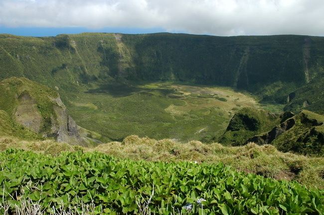
Cabeço Gordo (Portuguese for "fat mountain") is the highest mountain, massive stratovolcano and the largest geomorphological structure that forms the island of Faial. The mountain/volcano is 1,043 meters above sea level, consisting of a two kilometer wide caldera, that is 400 m in depth below the crater rim. From Cabeço Gordo, on a clear day, the islands of the central group of the Azores are visible: Pico, Sao Jorge, and Graciosa, although normally the caldera may be covered in clouds and fog.
Contents
Map of Cabe%C3%A7o Gordo, Portugal
History
Along the western edge of the Ribeirinha Volcano, the Central Volcanic Complex formed about 410,000 years ago, along with several structures that arose from tectonics. Evidence of this process has not been preserved due to subsistence, but it is generally believed that two formations (an Upper and Lower group) reflecting a geochemical variation that occurred about 16,000 years ago. The Lower group (from 410,000 years ago), was marked by the predominance of a Hawaiian/Strombolian eruptive process, that was composed of basaltic and benmoreitic rocks. The secondary, Upper group, was a highly explosive period (sub-Plinian in character), which produced a series of twelve deposits of pumice and surge deposits (pyroclastic flows of trachytic and benmoreitic).
Although the central volcano has not been active within the past two centuries, it has seen activity related to the eruption of Capelinhos (1957–58). During this period, fumaroles in the caldera became active, and the minor lakes/swamps were dried-up by excessive heat.
Cabeço Gordo, due to its central nature, is part of each parish on the island (except for Matriz, Conceição and Angustias).
Geography
Cabeço Gordo is the main geomorphological unit, corresponding to a polygenetic volcano two kilometers at the top and one kilometer at the base. The walls of the crater rim are abrupt, although their slopes increase with altitudes. The superficial cover of the volcano is covered in pyroclastic material, such as pumice rock, phreatic and phreatomagmatic deposits, evidence of pyroclastic flows and lahars. The flanks of the stratovolcano also include the Morro de Castelo Branco and peninsula of denser material that have resisted erosion.