
Location Guinbirayan Bay Length 2 km (1.2 mi) Highest elevation 85 m (279 ft) Elevation 85 m | Adjacent bodies of water Sibuyan Sea Width 1.5 km (0.93 mi) Region MIMAROPA Archipelago Romblon | |
 | ||
Cabahan (also known as Cabangahan or Puro Island) is an island in the province of Romblon in the Philippines. It has one sitio named Cabangahan, which is a part of barangay Guinbirayan, Santa Fe, Romblon. The local name of the island is Puro, which means "Island" in Onhan language; which is the native language of the island's inhabitants.
Contents
Map of Cabahan, Santa Fe, Romblon, Philippines
The island was formerly an island barrio of Santa Fe, Romblon that existed from 1901 to 1917. In the 1903 Census on population, it had 24 residents.
Geography
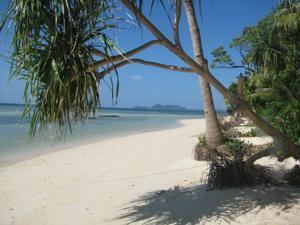
Cabahan Island, lying off on the eastern shore of Santa Fe, about 3 miles (4.8 km) NNE of Cabalian Point (the southernmost tip of Tablas Island, is wooded and 279 feet (85 m) high. Its south and east shores are formed by red, rocky cliffs, and its west and north shores are bordered by mangroves. A rocky islet about ¼ mile (0.40 km) East of Cabahan is joined to it by a reef and about ¼ mile (0.40 km) south-southeast from the southeast point of Cabahan is Pez Rock, a red pinnacle 70 feet (21 m) high, between which and Cabahan, the water is deep.