
River mouth Viaur305 m (1,001 ft) Length 56 km | Basin size 340 km (130 sq mi) Basin area 340 km² | |
 | ||
Main source Salles-Curan910 m (2,990 ft) Discharge Average rate:4.6 m/s (160 cu ft/s) | ||
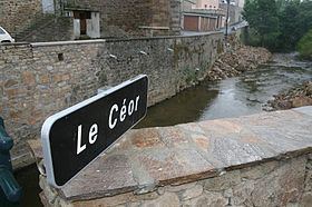
The Céor (French: le Céor) is a 55.9 km (34.7 mi) long river in the Aveyron département, southern France. Its source is at Salles-Curan, 3.5 km (2.2 mi) southwest of the lac de Pareloup. It flows generally west-southwest. It is a left tributary of the Viaur into which it flows at Saint-Just-sur-Viaur.
Contents
Map of Le C%C3%A9or, France
Communes along its course
This list is ordered from source to mouth:
References
Céor Wikipedia(Text) CC BY-SA